

Concerns expressed over Flatt Point sub-division plan on south shore
Administrator | Nov 24, 2025 | Comments 5
By Sharon Harrison
“Going blindly forward with this sub-division will amount to approving a plan that will forever impact the very ecological features it claims to protect,” said Amy Bodman, on behalf of the Prince Edward County Field Naturalists.
“Building sub-divisions in rural areas is exactly opposite to what we should be doing if we are serious about a climate emergency,” voiced Cheryl Anderson, on behalf of the South Shore Joint Initiative, and the Prince Edward Point Bird Observatory.
The proposed Flatt Point sub-division on County Road 13, on-going in the planning process for at least five years, was before the planning and development committee meeting last week.
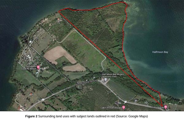
The applicant (Michael Kerford /712223 N B Ltd.) has submitted applications (third submission) for a draft plan of sub-division, a draft plan of condominium, official plan amendment and zoning bylaw amendment for 17 new residential lots, approximately one hectare each in size, the majority having water frontage on Halfmoon Bay.
It should be noted these applications were filed before the 2021 official plan (OP) was approved, and are being evaluated under the 1998 and 2011 consolidation official plan.
Councillor John Hirsch indicated how the application was filed approximately one month before new OP came into effect, and asked why it has taken four years to get to this point.
“This was, at that time, a rather inadequate application… the access road had not been determined, so landlocked parcels, and it has been landlocked for a long time, which is why no one has been able to develop it,” explained Hirsch.
“The reason, of course, for having it be looked at under the old OP is that, under the new OP, we wouldn’t be here tonight because this property falls fully within a natural core area of the new OP which would not allow this kind of development.”
Under a two-step process adopted in January 2025, no decision on this planning application will be made by council at this first statutory overview meeting, which is intended as information-gathering only. Decision by council can happen at a future second statutory public meeting where staff will provide a report and recommendation.
Of note, the property does not have any frontage on a maintained public road, but has approximately 1,276 metres of frontage along an unopened road allowance connected to County Road 13 at the south end of the property.
All but one of the 17 lots will be accessed via a private condominium road (ending in a cul-de-sac), with an official plan amendment required to establish and permit access (a right-of-way) via the proposed neighbouring property for the private condominium road.

Pertains to the second application for technical consent for the right of way
The proposed condominium road crosses the abutting property at 3287 County Road 13 and a separate easement companion application has been submitted to establish a right-of-way over the abutting property. The technical consent application filed by South Bay Estates Inc., also being considered at this meeting, would create an easement for 3271 County Road 13 (Half Moon Bay Winery) that would establish a 14-metre-wide, 580-metre long right-of-way over the proposed sub-division property (3401 and 3287 County Road 13).
“The application is supported by the PPS (provincial planning statement) in terms that it is supporting rural residential development,“ said Mark Touw, of the Boulevard Group, agent for both applicants.
Councillor comments and concerns ranged from rural settlement areas and where residential growth should be focused, to the lack of housing styles, flooding worries and the 100-year floodline, to concern about the application being considered under the old OP.
Referencing the 2006 OP on settlement growth, councillor Sam Branderhorst stated how sub-division development is encouraged in urban centres, and may be encouraged elsewhere, but “it is supposed to be specifically discouraged in rural designations. This is a rural designation, so how does that fit our plan?” she asked.
Touw explained the shoreland designation in the old OP did more specifically allow rural estate sub-divisions. “No denying certainly that residential growth should be focused primarily in settlement areas, and then rural settlement areas, then having a limited range of residential in rural areas.”
He further noted the new OP does not allow sub-divisions in rural areas, and limits consents to one. “But the fact remains under the old OP, which is how these applications are to be evaluated, there was allowance for rural estate sub-divisions.”
“I understand that we may do it, we are allowed to do that, but does it fit in many ways. I feel like we are trying to put a square peg in a round hole,” said Branderhorst. “It’s not feeling like it fits the plan and its more seeming like we are trying to make a plan fit something that is not supposed to be there.“
Councillor Kate MacNaughton said she was “generally not supportive of this”, adding, “I don’t think we should be entertaining this, or supporting this”.
Located at 3401 County Road 13 (north side) in Milford (South Marysburgh), the property comprises 22.1 hectares of vacant undeveloped lands (characterized as primarily naturalized areas), abutting Lake Ontario on Prince Edward Bay and Half Moon Bay with extended waterfront.
Fifteen hectares of the 22 hectare parcel would be used for the proposed sub-division, with the remaining seven hectare portion to remain as wetland open space.
Six members of the public spoke to the applications, including several nearby neighbours, as well as representatives from local environmental groups, each one voicing and highlighting various concerns to the proposed sub-division, especially as it relates to environmental issues.

Legend shows red dots as floodline hazard and blue line as 100-year floodline
Those concerns included inconsistent studies (the accuracy of the 100-year floodline and the site elevation figures), the mass clear-cutting proposed, flooding on the property (especially in 2017 and 2019), to questioning why the Blanding’s turtle was not mentioned in the environmental study despite having been observed over recent years.
Michael Toccalino, a retired landscape architect, has had a summer property on County Road 13 for about 40 years. He spoke to the property’s development history, the proposed clear-cutting of about 83 per cent of vegetation on the site, but also most notably he spoke to the 100-year floodline and disputed the indicated elevation of the site.
He reminded that a proposed sub-division for the Flatt Point site was denied in 1978, where he noted how the zoning bylaw remains the same. “That indicates that no building or structure shall be erected or used closer than six metres: at best, Flatt Point is only four meters above the lake.”
He also noted that in many places in the submitted documents (where he provided several examples from several studies), it is noted the site is at an elevation of about 80 metres above sea level, which is about four metres above the current lake level, something he disputes.
“Knowing the site to be relatively flat, I was suspicious that it should be listed as 80 metres above sea level,” said Toccalino, where he demonstrated just how low the site is relative to the lake. He indicated that 39 per cent of the site (around the perimeter) is an area that is between zero and one-metre above the lake level and 65 per cent of the site two metres above sea level.
“In 2017, the water was as high as I’ve ever seen it: it was over our shore well, and our shore well had to be at the 100-year floodline, and the water was higher than that. Sixteen septic systems that close to the lake is a real problem.”
In response, Touw said the conservation authority are responsible for protection against flooding and other hazards, confirming they assessed the application and “did not identify any concerns with respect to flood hazards in the developable area of the property based on current floodplains”.
Another speaker noted how they are called the “Flatts” for a reason.
Cheryl Anderson, representing the South Shore Joint Initiative and the Prince Edward Point Bird Observatory reminded how Flatt Point lies within South Shore’s key biodiversity area (KBA) with such designation demonstrating global significance for conservation. Flatt Point also lies within a natural core area in the South Shore, as per the 2021 OP.
She highlighted concern for the wetland areas at the proposed development site, how the area is a bird migratory route and refuge, along with concern for a lighter dark sky (bad for animals and people), outlining the importance of maintaining natural core areas especially for species at risk, increased road traffic on an already busy road, as well as addressing environmental responsibility.
“In general, increased development in the South Shore KBA is a bad idea,” said Anderson.
Amy Bodman, representing the Prince Edward County Field Naturalists also raised a number of points, including that by 2021 OP standards, the site is in a natural core area “where major development is deeply discouraged”.
She also spoke to an out-of-date EIS (environmental impact study), the impact on natural features including servicing infrastructure, the destruction of a 19-acre significant woodland, the cumulative effects on migratory birds, species-at-risk and wildlife, as well as noise and light pollution.
“The concept plans confirm the woodland will be gutted for the sub-division with the 50-metre setback the EIS recommends,” said Bodman. The designation of significance becomes meaningless when the very woodland feature that warranted protection is developed under the guise of compliance.”
The applicant proposes a 50-metre setback from the water and rear of the property line to provide greater protection to the water and providing connection to wetland open space area.
“The 2024 PPS speaks to providing a range and a mix of housing options, it provides for development in the rural areas which includes a range of uses whether its rural residential, agricultural, other resource dependent uses,” said Touw, “so the PPS does contemplate a full range of uses in the rural area.”
The wetlands and the southern portion of the property, described as a provincially non-significant coastal wetland, are not proposed to be included as part of the proposed sub-division.
“The owner intends to ensure the wetland and associated length of shoreline is conserved in perpetuity through its dedication to a nature conservancy non-profit organization, the conservation authority or similar, to ensure its long-term preservation,” notes the planning justification report.
“The property is understood to have been the subject of previous sub-division and zoning bylaw amendment applications which received some form of approval in approximately 1978,” notes the planning justification report. “It is understood that the previous sub-division did not ultimately receive final approval and/or the sub-division lapsed or was deemed. The zoning approved for the previous sub-division was enacted and is in place currently.”
Touw subsequently confirmed that “deemed” is a planning term, where he said to deem a sub-division means it is no longer a sub-division under the planning act.
Planning documentation relating to these applications can be found on the County’s website.
~ ~ ~
Audience comments from Cheryl Anderson, Amy Bodman and Paula Peel are included below, in their entirety, for ease of reference given some of the virtual speakers experienced poor audio quality due to the County’s technical problems.
Cheryl Anderson on behalf of the South Shore Joint Initiative and the Prince Edward Point Bird Observatory:
“Flatt Point lies within Prince Edward County’s South Shore key biodiversity area (KBA). A KBA designation demonstrates global significance for conservation. KBA’s help identify and protect areas important to biodiversity. The KBA designation brings attention to the need for more and better habitat protection for species-at-risk and, in fact, all flora and fauna.
Flatt Point is within the South Shore natural core area (NCA) as shown in Prince Edward County’s official plan (schedule B). Neither the environmental site assessment nor the environmental impact study (EIS) for this proposed development adequately address the requirements of the 2021 official plan. Both studies need to be brought up-to-date regarding species-at-risk.
The development site contains two unevaluated wetlands which are potential habitat for the western chorus frog. The Great Lakes St. Lawrence population of the western chorus frog is listed at threatened in the species-at-risk act. Snapping turtles are frequent in the County and can live in and forage through small wetlands, and Lake Ontario shorelines. They are characterized as special concern in the endangered species act and the species-at-risk act. Other potential herptile [reptiles and amphibians] species-at- risk for this site include Midland painted turtle, eastern milk snake and northern map turtle. An expanded EIS should be required before an approval of this proposal.
In general, increased development in the South Shore KBA is a bad idea. Increased development brings more traffic on the roads; more light in the dark sky. County Road 13 has recently been resurfaced; the extra traffic because of access road construction, building 16 houses and ancillary sheds and garages will cause undue stress on the road, dangerous situations for walkers and bicycle riders, and more dead on the road wildlife. The extra people and vehicles will stress an already a very busy road.
As described recently by SSJI board member Steven Burr, South Marysburgh has experienced reduced darkness in the last few years. It is simply not as dark as it once was, because of increased development. All creatures require a daily period of darkness. By allowing increased development the South Shore we will begin to approach urban levels of light. The much-valued rural surroundings are being degraded.
The South Shore of Prince Edward County is renowned as an avian migratory refuge. Despite the proposal’s environmental studies, the Flatt Point site should be considered important for avian migration. General stopover areas of birds on migration are considered to have a radius of 25 kilometres or more from initial touchdown. The Flatt Point site is well within that radius from Prince Edward Point. If, as the consultant agrees in the response to the peer reviewer that the whole Prince Edward County South Shore is important for avian migration, then certainly this piece and every piece of the South Shore is important. Any one piece of the South Shore cannot be considered different, or more or less important than any other piece.
Prince Edward County council has declared a climate emergency. Climate change can be ameliorated by maintaining natural area conservation and by reducing dependence on fossil fuels. Building subdivisions in rural areas is exactly opposite to what we should be doing if we are serious about a climate emergency. There is no indication on any of the documents I have read about a requirement for additional electrical infrastructure to support, for example, all electric houses and electric vehicle charging stations in this sub-division. It means fossil fuel dependency for the sub-division and extra fossil fuel use for transportation to work to school and to the grocery store. This is a bad look for the County that is committed to being environmentally responsible.”
* * *
Amy Bodman, on behalf of the Prince Edward County Field Naturalists:
“Good evening. I’m here tonight on behalf of the Prince Edward County Field Naturalists (PECFN) to discuss the Flatt Point proposal, in particular its environmental impact study (EIS) and accompanying peer review. This proposal is of particular concern to PECFN because by 2021 OP standards it is in a natural core area where major development is deeply discouraged.
The EIS begins by saying that the purpose of an EIS is to determine if significant natural heritage features are present. That is not correct. As the County’s peer review states, the purpose of an EIS is “to outline the impacts of the proposed project and determine if there will be a negative effect on the natural heritage features”. This has not been done.
Another objection of PECFN is that we have only an out-of-date EIS to respond to. The proposal to put a road directly within the coastal wetlands on the property has been a hot-button topic for years. The peer review notes that the road system needs to be addressed in the EIS. The EIS itself notes the need for mitigation and wetland compensation if the unopened municipal road allowance is used. Yet planning staff recently told PECFN the route for the road system has been reconfigured to avoid going directly through the wetland and that it appears that the EIS is being revised to reflect this. Without a revised EIS we cannot know this for sure.
The MNRF (Ministry of Natural Resources and Forestry) Natural Heritage Reference Manual states that the EIS must evaluate all components that could impact natural features, including servicing infrastructure. The peer review raises the concern that infrastructure including water, sewage and utilities need to be addressed in the EIS. Before we can even begin to assess impacts on environmentally sensitive features such as coastal wetlands, significant woodlands and undeveloped shoreline, we need to know where electrical components, wells and septic systems will be located.
The peer review notes the sub-division is proposed in a significant woodland. It’s a 19-hectare woodland that is within five kilometers of Lake Ontario. It supports an adjacent significant natural feature such as fish habitat or a water body. The EIS itself confirms that this woodland is designated as significant based on MNRF criteria for proximity and water protection.
Nevertheless, the concept plans confirm the woodland will be gutted for the sub-division with the a 50-metre setback the EIS recommends. The designation of significance becomes meaningless when the very woodland feature that warranted protection is developed under the guise of compliance.
The EIS does not provide a clear, quantitative assessment of the amount of vegetation that will be removed by the proposed sub-division.
There is no analysis of cumulative effects on migratory birds or species-at-risk that takes into account the rapidly-increasing loss of the shoreland linkage function due to increased development along the shoreline.
There is no mention of impacts on wildlife like the whippoorwill or other migrating species from traffic. There is limited discussion on nearshore aquatic eco-systems and potential sedimentation during construction.
There is no mention of light and noise pollution, such as an assessment of artificial lighting impacts on nocturnal migrating species including bats and noise impacts on sensitive wildlife.
Chemical run-off into the wetlands or into Half Moon Bay from the use of pesticides and herbicides is not addressed. Nor is cumulative recreational pressure on sensitive shoreline areas and in the wetlands on the property.
The EIS confirms that a wetland evaluation study has never been done. We do not know if these wetlands are significant or not. Nevertheless, the EIS and other reports emphasize on a consistent basis that the wetlands on the property are non-significant.
A revised EIS has not been provided for this statutory public meeting, denying both the public and council the means to comment on the most up-to-date environmental impacts of the proposal. The existing EIS does not begin to scratch the surface in identifying and addressing the potential impacts to the woodlands, wetlands, shoreline nor to the migratory birds, fish habitat and vegetation they support. Going blindly forward with this subdivision will amount to approving a plan that will forever impact the very ecological features it claims to protect.”
* * *
Paula Peel:
“Good evening, my name is Paula Peel. I am here to argue that the proposed Flatt Point sub-division conflicts with the guiding principles and intent of the 2024 provincial planning statement (PPS) and the 2011 official plan which this proposal falls under.
First, the PPS. The 2024 PPS emphasises three key priorities. First, the need to increase housing supply where demand is greatest. Second, the need to promote compact, efficient development aligned with infrastructure and services. Third, the need to support a range of housing types, especially affordable options.
Flatt Point does not meet a single one of these priorities.
As noted, the intent of the PPS is to increase housing supply in areas where demand is greatest. This sub-division is proposed in an isolated, rural patch on the County’s south shore in one of the County’s natural core areas, which the OP identifies as areas that need special protection due to their high ecological value.
Second, this is not a compact or efficient development that’s aligned with infrastructure and services. This is urban sprawl. The sub-division, located 27 kilometres from Picton, will increase traffic during construction, and afterward, as residents travel for services. It’s far beyond the reach of municipal water and sewer systems. It consists of 17 large building lots with each lot serviced by individual private wells and septic. The sub-division occupies 22-hecatres of shoreland with building lots covering about 17 hectares. This is opposite of compact and efficient land use.
Addressing the third priority, this proposal fails to provide a range of housing types, instead of affordable or missing middle options, like duplexes, townhouses and low-rise apartments, the range of housing types that the PPS supports. This proposal intends to create a high-end enclave with a private condominium road and privatized open space.
This sub-division is effectively a gated community without the gate. Although a gate could conceivably be added later by the condominium corporation that oversees this road. These are large four-bedroomed homes on two to three acres of land, not homes for the people who need them most.
This proposal envisions an inclusive shoreland retreat for the wealthy.
The proponent claims the project increases housing options in rural areas, but the PPS links availability with affordability. And this proposal clearly fails the affordability test.
And while the 2024 PPS gives municipalities more flexibility to allow rural housing, it still directs growth to settlement areas. This sub-division lies well outside any settlement areas.
In short, the Flatt Point sub-division does nothing to support PPS housing priorities. It undermines efforts to address the County’s critical housing needs; it will put housing in rural areas out of reach for most because high-end sub-divisions like this generally have the effect of
increasing the overall price of houses in the surrounding area, not the opposite.
I also want to quickly consider the 2011 OP which applies to this application.
This sub-division proposal will contradict several policies in the 2011 plan. The applicant has already requested an OP amendment to over-ride policy 4.3.3. that requires access to sub-divisions by a publicly-maintained, year-round road.
But there are two other relevant policies.
The policy in section 6.3.1. that says, “very limited new development will be permitted in rather isolated areas, such as Long Point and Point Petre”, and the policy is section 4.4.2. that requires open shoreland and cluster divisions to have a minimum of three and a maximum of 15 lots. Flatt Point proposes 17 lots, exceeding this limit.
It appears that additional amendments are needed to over-ride those very clear policies in the 2011 plan. This alone should raise a red flag.
In the bigger picture, this proposal offers no public benefit whatsoever beyond increasing the tax base. It does not address the County’s need for affordable and diverse housing, and it makes this problem harder to address as it will ultimately increase property prices and house values in South Marysburgh.
It clears the way for more high-end condominium, read privatized, sub-divisions along large segments of the County’s shoreland in this way permanently removing the shoreland from public use and enjoyment.”
Filed Under: Featured Articles • Local News
About the Author:


Council should have said no to the location for the Campfire Circle due to its environmentally sensitive location, with ALL the appropriate legal environmental protections in place, with all the “i’s dotted and t’s crossed”. But they didn’t. Don’t see a whole lot of backbone in Shire Hall for the residents of the County. The developers seem to rule and something’s gotta give.
As a resident on County Road 13, not far from this site, I have grave concerns if this development proceeds. With zero frontage on a municipal road and in an environmentally sensitive location, this cannot be the acceptable site for such a development. Time for Council to grow a backbone and say NO to this application.
Oh good heavens, yes. Let’s ask our Council to tackle the Ontario Land Tribunal (OLT) with this one. Just like they didn’t do for the residents regarding the Picton Terminals. Just like they didn’t do for the 30+ year effort of volunteers to protect the Warings Creek Watershed. etc.etc.etc.
Just a little something to think about with regard to the OLT. The following was in response to my recent request for information concerning the balance in the 2025 budget for use for OLT cases:
“In response to your inquiry regarding funding available for Ontario Land Tribunal (OLT) matters, please note that costs related to OLT are paid from the Planning Department’s legal budget. As of the end of October 23rd 2025, approximately $28,465 remained in that budget. However, these funds are used for a range of legal matters, not exclusively for OLT proceedings.”
While the application got in under the wire on the OP changes the new Provincial Planning Statement (2024) applies not to the date on which an application but to any DECISION taken after October 20th, 2024 which was when the PPS came into force. There are numerous instances of this application not meeting the PPS requirements. If it doesn’t, then Council has not only the right but also the duty to reject it. The Ontario Land Tribunal is generally supportive of protection of natural core areas and key biodiversity areas so any appeal by the applicant would probably fall on deaf ears.
Developers aren’t daft, and it’s all in the timing. In this particular case, one month.
Council should definitely have the right to refuse this application citing the most up-to-date OP, and anything from anyone not already making its way through our regulations on an official filing basis, should also be put back to square one. Rushing to file a month ahead of new regulations is more than a bit cheeky, blatant and uncalled for. They had to know or, at the very least, ought to have known that there would be push-back in this particular location.
One month. Geeeeeeeeeeez.