

Full house for historian’s ‘flashback’ on County’s ‘west coast’
Administrator | Feb 25, 2020 | Comments 1
By Sharon Harrison
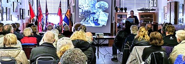
There was standing-room only at Consecon’s Legion as local historian Marc Seguin, gave a presentation on one of his favourite topics – Wellers Bay.
Part of the week-long Flashback February series of events organized by the County Museums, saw around 60 people in attendance.
Karen Fischer, a newer resident to Wellers Bay, and the Chairperson of Friends of Wellers Bay, one of the sponsors for the event, introduced Seguin as a local historian who has lived on Wellers Bay for about 18 years.

Marc Seguin – Sharon Harrison photo
Seguin is an author of several books and he lectures on Great Lakes marine history. He is also a founding member of the heritage organization Save our Lighthouses, and he is vice-president of the Prince Edward County Historical Society.
His talk on Wellers Bay Marine History touched on the varied history of the area, including ships, storms, canals, lighthouses and railways.
“Welcome to the West Coast!” he began. “The main feature that dominates the west coast in Prince Edward County is Wellers Bay,” he said, adding that the area has a very long and fascinating history.
He offered a brief look at the region’s natural history and pre-history.
“The most prominent feature of Wellers Bay is the strip of sand that separates the bay from Lake Ontario. The sand spit is known as a barrier beach, or baymouth bar.
“Technically though, geographers classify Wellers Bay as a lagoon,” Seguin said. “Many millennia ago, glaciers covered all of this area, where eventually the glaciers melted and they formed The Great Lakes,” he said. “In the process, large deposits of sand were left behind.”
He explained that in Lake Ontario, the sand was eventually carried along by currents until it hit pre-glacial limestone outcroppings, which were remnants of ancient sea beds.
“Wherever these limestone headlands would appear, they would slow down the current and then sand would settle around the rock, eventually forming the large barrier beaches.”
He noted that over thousands of years several of the barrier beaches were formed, with lagoons behind them.
“Today, we have named these lagoons East Lake, West Lake, Huyck’s Bay, Pleasant Bay, North Bay and Wellers Bay.”
Seguin noted that archeological evidence indicates there was human settlement at various places around Wellers Bay starting thousands of years ago.
“Some of these settlements were likely made by one or more Helios cultures, those are the earliest societies that used only tools made from bone and wood and stone,” explained Seguin. “For centuries this area has been a hunting ground and was used as a passageway by war parties and various Indigenous tribes.”
Seguin noted some of the early explorers and missionaries to the area kept journals and rough sketches of their journeys, and sent the information back to Europe where cartographers were able to piece together maps of these new territories.
He noted many of the 17th and early-18th century maps don’t show Wellers Bay.
“It was only with the influx of Loyalists into Canada after the American Revolution that comprehensive land surveys were done and maps, such as this 1796 example, finally show a somewhat accurate depiction of the bay.”
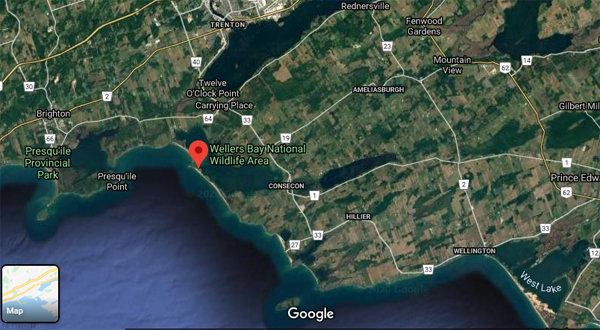
Wellers Bay – Google maps image
He said the earliest detailed map of Wellers Bay is from 1802, but noted it wasn’t yet called Wellers Bay. One map shows it was called Lake Edward. Seguin also noted that the Bay of Quinte was called Trent Bay, and Presqu’ile Bay was called Newcastle Harbour.
“It wasn’t until after the War of 1812, when the Royal Navy surveyed much of the north shore of Lake Ontario that this is one of the first times the name Wellers Bay was shown on a map,” he said.
Asa Weller is said to be the first permanent resident of European descent to settle along the carrying place near the bay.
“The Wellers were originally palatine Germans who had emigrated in the early 18th century to the US, settling in Vermont. At around 1800, the late-Loyalists came to Canada, built a log cabin on the north side of the Carrying Place, west end near the shores of the bay that eventually took his name.”
Within a few years, he had built a fine brick house explains Seguin.
“The house is still standing today at the corner of County Road 64 where the Portage Road and Gardenville Road meet,” said Seguin. “And that part of the bay that was closest to Asa Weller’s property was for a long time informally known as Wellers Bay, while the portion of the bay closer to Consecon was often called Consecon Bay.”
Decades later the entire lagoon was officially named Wellers Bay.
When Asa Weller settled here the only efficient means of transportation from place to place was by water, said Seguin. Bateaus and schooners were the earliest vessels on Lake Ontario and the Bay of Quinte to transport both cargo and passengers.
“By the 1820s, larger sailing ships and steam boats were also becoming quite a common sight on the Great Lakes,” he said. “When Asa Weller arrived on the shores of the Bay of Quinte, he saw the potential of the area as a major transportation hub.”
Seguin further explained that Weller established a railroad across the portage, or the carrying place.
“He used hardwood rails, he laid them from Wellers Bay to the Bay of Quinte, and he used a large ox cart on the rails to haul goods and people and lumber, and even boats that were laden with cargo, all across the portage.”
“This really was one of the first railways in North America,” Seguin noted.
He also said that while the area was developing into something of a transportation hub, even as late as 1850, the only vessels that could travel on Wellers Bay were canoes, row boats and bateau.
“The link to Lake Ontario was just too narrow and too shallow to allow anything larger to gain access to the bay.”
A series of winter storms in 1854, 1855 and 1856 changed all of that, he explained.
“In late winter and early spring for three years in a row, huge chunks of ice broke up and were blown ashore to form what are often called ‘ice shoves’”, he said. “Then violent storms from the west would often pile up more and more on the Lake Ontario side of the barrier beach, and the wind and waves were so strong, the ice was literally ‘shoved’ right through the beach.”
The giant piles of ice eventually obliterated the northern stretch of dunes, and they transformed the tiny outlet into a channel 150-feet wide and 14-feet deep.
The first ship in history, the steam boat Chief Justice Robinson, entered Wellers Bay in June 1856, and this was the beginning of a new era for Wellers Bay as a safe harbour on Lake Ontario.
“The village of Consecon, at the far end of Wellers Bay, would really benefit the most from shipping now that they could now enter the bay,” he said. “Already in the 1850s, Consecon was a thriving village; at the time it really was only second to Picton in the County.”
There were shops, three churches, three mills, two hotels and a distillery.
Shortly after the Chief Justice Robinson sailed into Wellers Bay, many ship owners and ship captains and private citizens petitioned the Canadian legislature to make Wellers Bay a harbour of refuge. “They wanted buoys and lighthouses set up to guide ships into the bay.”
The waters of Lake Ontario off Prince Edward County were so dangerous and so many ships were sunk there that this area became known as The Graveyard of Lake Ontario.
“By 1856, five substantial lighthouses had been constructed to guide ships along these hazardous shores,” Seguin explained. “But there was still no safe harbour between Presqu’ile Bay and South Bay at other end of Prince Edward County.”
Wellers Bay would make an ideal harbour of refuge, and compared to other suggestions, Presqu’ile Bay for example, it was determined that Wellers Bay would make the better harbour for refuge.
“One catch was the rocky shoal which seems to obstruct the entrance to Wellers Bay.”
After decades of debate, finally in 1875, it was determined the shoal did not exist, the government allocated $2,500 for a new lighthouse on Wellers Bay.
“The Wellers Bay range lights were constructed in 1876 at a cost of $1,444, amazingly $1,000 under budget,” said Seguin. “The two lighthouses were located at the end of the Portage Road on Bay Farm.”
“The lighthouses on Wellers Bay were two of more than 40 lighthouses in eastern Lake Ontario waters that helped guide ships to safe harbours through the graveyard of Lake Ontario.”
By 1876, there were six lighthouses in the vicinity; two in Wellers Bay, two in Presqu’ile Bay, one on Presqu’ile Point, and one on Scotch Bonnet Island.
“While these lighthouses were valuable aids to navigation, they were not able to prevent shipwrecks,” he said. “The combination of wild weather and treacherous shoals all around the County, especially here on the County’s west coast, led to many ship sinkings, and loss of life.”
For more than a decade after, several tragedies involving the Garibaldi and Belle Sheridan, the Canadian government received petitions to establish a life-saving station on Wellers beach
“The first life-saving station on the Canadian side of the Great Lakes had been established at Salmon Point in 1871,” explained Seguin. That station was later moved to Long Point, and later still to Wellington beach. In 1898, the station was moved to Wellers beach where $750 was provided for a self-righting, self-bailing lifeboat.”
Throughout the last half of the 19th century, Consecon had developed into a very busy town.
“It was growing as a shipping port for lumber, apples, grain and fish, all being exported to the US, and the town eventually became a customs port ,so US registered ships could load and unload cargos here.”
One of the on-going problems with Wellers Bay harbour was the shifting sands of the barrier beach.
“To remain effective as range lights, the lighthouses on Wellers Bay had to be relocated twice, once in 1889 and again in 1892,” said Seguin. “Finally in 1909, the rear range light was discontinued. The next year, the front range light was shut down, and both lighthouses were demolished.”
During the 20th century, commercial activity in and around Wellers Bay severely declined.
“Commercial fishing continued throughout the 20th century, and even today there is a small commercial fishery in the bay.”
The barrier beach at Wellers Bay was used as a gunnery range and a bombing range in 1938 by the Royal Canadian Air Force where they dropped practice bombs. By the Second World War, it was used a rocket range.
“There are still thousands of shell casing from 303 and 50-calibre machine guns and 20 millimetre canon all littering the lake bottom and all the beaches all around the bay “ explains Seguin. The range was closed in 1956 and was declared a restricted National Wildlife Area in 1978.“
The beach and the bay continue to be used for army reserve training and search and rescue training he said.
“The Department of National Defence still believes there are a number of unexploded bombs somewhere in the dunes, but they have spent thousands and thousands of dollars looking for them, with no success.”
Filed Under: Featured Articles
About the Author:


I appreciate Sharon Harrison’s article detailing Marc Seguin’s presentation.
I was unable to attend the event but enjoyed reading the summary.