Enhanced cycling areas, congested traffic top citizen concerns for long range transportation master plans
Administrator | Dec 09, 2020 | Comments 3
By Sharon Harrison
Enhanced cycling areas and improving congested traffic areas were top concerns expressed in feedback for draft recommendations to how transportation should look in the County.
In follow-up to a Transportation and Cycling Master Plans public meeting held at the end of August, the meeting looks at what a long-range plan for what cycling, walking, vehicle and transit network could look like in Prince Edward County.
This second stakeholder meeting saw 18 participants where the virtual update incorporated a presentation on the findings and the feedback from the last meeting with draft recommendations.
Partnering with Toronto-based consultancy firm WSP, representatives from the municipality presented two master plans, one covering transportation, the other specific to cycling. The process, which has been on-going for about a year, is being undertaken under the Municipal Class Environmental Assessment (MCEA) process.
Working on the master plans were the County’s John Gooding and WSPs Brett Sears and Jillian Britto who came up with the Transportation Master Plan (TMP). The County’s Emily Cowan and WSPs Shawn Smith put together the Cycling Master Plan (CMP).
The project, currently in phase two, hopes to have a draft Transport and Cycling Master Plan ready for council’s consideration and endorsement at the beginning of next year. A 30-day public review would follow.
Sears noted the public engagement during the process thus far, including meetings with stakeholders, where he indicated many of the public comments received were on cycling.
He noted a survey was undertaken that saw 1600 website visits, with 82 survey responses, with 54 per cent of respondents indicating they live and work in Prince Edward County.
Top priorities were identified from responses surrounding how cycling can be enhanced through an interconnected network that is efficient and safe.
“We also want to preserve the atmosphere in the County because we recognize that’s why you might live there, and that’s why people like to go visit there.”
“What we have heard from the different stakeholder sessions is that the current conditions are really only meeting the needs of the people driving,” said Sears. “Having a specific Cycling Master Plan is trying to broaden the options, help create more viable travel options for how people get around within the County.”
He noted that multi-modal (different modes of getting around, not just driving) and safety are a top priority, noting competing priorities in terms of local movement, tourism, space for active transportation and other modes.
“Recognizing it’s a big place and the budget is always finite,” added Sears.
 CYCLING RECOMMENDATIONS
Shawn Smith, with WSP, spoke about walking and cycling, saying the priorities are about improving safety within the urban areas, but also connecting to key destinations, such as parks, shopping, schools, restaurants, and particularly the Millennium Trail.
He outlined the approach to creating long-term infrastructure vision for the pedestrian network.
Smith said they started by identifying the existing conditions, such as the where the sidewalks and paths are, as well as establishing some route selection criteria, identifying candidate routes through field investigations.
“We also heard some comments about sidewalks needing maintenance and upgrades, but that is really beyond the scope of this project,” he said.
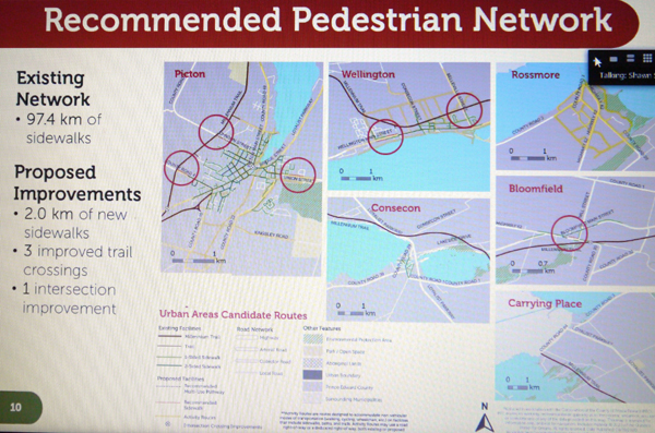
The existing network is more than 97 kilometres of sidewalks.
Smith said the recommendation proposes two kilometres of new sidewalks in key areas, particularly connections with the Millennium Trail, something he describes as a “wonderful asset” and “the spine of the active transportation network”.
The group identified gaps such as on Wellington Main Street, as well as connection to Macaulay Mountain Conservation Area and other similar locations.
A few trail crossings were also identified where the Millennium Trail crosses a major road and could be upgraded to improved safety and comfort for pedestrians and cyclists.
Smith also identified intersection improvement where Picton Main Street intersects with Town Hill.
“In terms of cycling, we took a similar approach identifying the existing conditions and facilities, paved shoulders, multi-use paths, bike lanes and trail, and established the route.”
Included are scenic routes and tourism access, also again featuring the Millennium Trail.
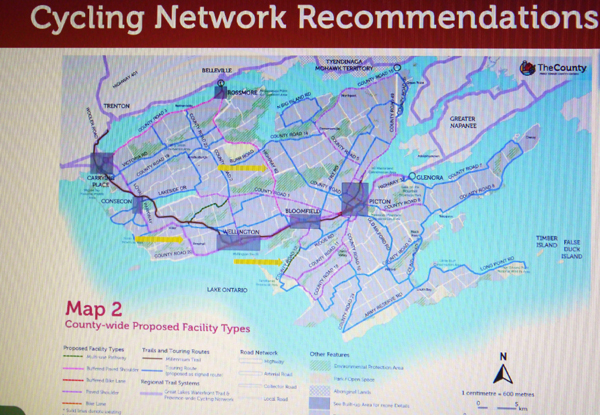
“Building on the spine of the Great Lakes Waterfront Trail which follows the Loyalist Parkway Highway 33 corridor, connecting Wellington, Bloomfield and Picton,” said Smith.
Smith said they heard a lot of feedback about County Road 12 providing a better connection to Sandbanks.
“We are recommending a multi-use path in the boulevard alongside County Road 12 up to Ridge Road, and then bike lanes from there,” stated Smith. “We have also included a multi-use path on Closson Road; there are businesses along there frequented by residents and tourists and better access is required on that road.”
He noted too that through the consultation process, the property on Closson is quite narrow, so other solutions or facility types may be accommodated.
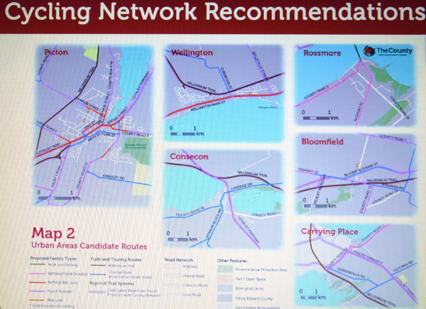
Looking at the urban built-up areas, for Picton, the recommendation is for re-allocation of road space on Picton Main Street to include a bike lane in the east-bound direction. It would maintain the existing lane configuration of one lane in each direction and parking on both sides.
“That would be paired with a bike lane in the other direction on King Street to provide both connections.”
 Smith highlighted five key recommendations that came out of the Cycling Master Plan.
The first is to use the Millennium Trail as an alternative to the Great Lakes Waterfront Trail, which spans beyond Prince Edward County and is part of the province-wide cycling network.
“We are proposing to still maintain the route on the existing shoulders of Highway 33, but designate the Millennium Trail as an alternate to the Great Lakes Waterfront Trail,” he said. This would mean that the junctions would be carefully signed, maps would be updated and there would be coordination with the regional tourist office.”
“Over time, with improvements to the surface and connections to the communities, the Millennium Trail would become the preferred route for the waterfront trail.”
The second recommendation is to include Highway 62 connecting Belleville where it connects with Highway 33 in Bloomfield, which spans about 25 kilometres. He said it also aligns with the work the MTO are doing to twin the bridge crossing to Belleville at Rossmore.
The third recommendation involves using the existing road space in a more effective way, such as narrowing lanes, shared lane markings, slower posted speed limits in built-up areas, and advisory bike lanes.
“Something new, advisory bike lanes, which is a different way to share space between cyclists and motorists and gives more priority to cyclists.”
The fourth recommendation is to update the paved shoulder policy.
The final recommendation is improving the cycling tourism experience, such as installing wayfinding signage, completing a bike parking inventory and adding high-quality parking in areas of need, working with businesses frequented by cyclists, creating a one-stop shop website and working closely with businesses to improve access to cycling.
TRANSPORT RECOMMENDATIONS
Brett Sears addressed transit with recommendations for the road network.
“For transit, we have tried to identify the existing conditions and services that are available in the County. We know that’s not extensive, but we at least want to understand what is being offered today,” said Sears.
He said opportunities and challenges were identified, and heard that people would like more transit.
“That is a challenge regarding the size of the County and the limited population; not a lot of density to support that transit, but we have been looking at viable recommendations for the Prince Edward County context.”
“One thing that we found was that we could show that transit belongs, such as bus shelters at stops that exist.”
He said there could be transit fare packages with incentives, such as for Via Rail passengers who could complete their trip to the County.
“There might be opportunity for more micro-transit or using existing services, such as taxi services or using smaller vehicles to be more demand responsive.”
Sears said they looked at the road network to examine the number of cars on the road and the capacity of that road to determine if there were any capacity concerns.
He noted the only area that was of concern was the bridge to Belleville at Rossmore, a part of Highway 62.
“We saw that even with a forecast population growth, the County road network is in good shape in terms of capacity.”
Sears noted that one of the issues is Sandbanks Provincial Park.
“It’s a tremendous asset for the County, but traffic congestion has been identified to and from the park, and sometimes people park on the side of the road unsure if they can get in.”
He said one viable solution is to have people register online in advance for day use, just as advance registration is a requirement for camping overnight, with a timed entry, which he says the provincial park are looking into.
Sears also noted that there has been discussions in the past about a bypass for downtown Picton.
“This is specifically for trucks, but people have noted traffic congestion along Picton Main Street and there are some safety concerns for cyclists and pedestrians.”
 He says the first alternative would be to do nothing.
“Some alternatives we came up with include a north and a south bypass to use existing roads to get around that key intersection at the Town Hill, and to alleviate truck traffic on Picton Main Street,” explained Sears.
He noted that the proposed southern route using Church Street to County Road 22, forms part of a residential street with a church and a school.
“We are thinking we only need a bypass for the northern route,” he said.
“Do we need a southern bypass?” he asked, and requests public feedback on this particular issue.
Sears said there was also discussion of using the Millennium Trail corridor to also provide a road.
“We see the Millennium Trail as one of the biggest assets in the County, so we wouldn’t necessarily want to spoil that in any way by having a road parallel to that,” confirmed Sears.
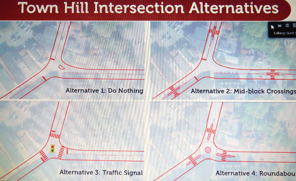
Discussing the Town Hill intersection and how to navigate it for the safety of pedestrians, cyclists and other vehicles using the road, Sears said they came up with a list of four alternatives for the Town Hill intersection improvement which he said is not an exhaustive list.
The first option is to leave it as is. The second is to provide some mid-block pedestrian crossing on the three legs, but not right at the intersection.
The third suggestion is to make the intersection signalized, noting in the past the concern has been about vehicles rolling back down the hill if they were to stop at a red light.
The fourth proposal is a roundabout, but Sears noted that a roundabout would be a challenge for the space available, especially for trucks, and which may involve property acquisition involving a heritage building.

A video of the presentation and related documentation is available at https://haveyoursay.thecounty.ca/tmp-cmp, where comments and feedback from the public are encouraged by Dec. 11, if possible.
Filed Under: Local News
About the Author:


The County reconfigured Main St a few years ago on the north side in front of Metro and Sobey’s Plaza so that cars could pass those turning left into the shops. To put in a bike lane going east on Main would take away the turning lane causing traffic to again slow to a crawl.
Having bikes along Main Street would only add to the summer traffic. Back streets with bike stands would be a better idea so that cyclists could leave their bikes and walk to Main Street.
In a world where have a limited budget, not to mention being in a pandemic for the better part of a year and associated ongoing uncertain costs resulting, there needs to be priorities.
This is an alternative mode of transportation that is generally restricted by weather from about November to March or April. Is the consultant applying a generic big city solution to a community of a few thousand? How many people are going to bike to Belleville along 62? If the answer is “some” does that justify the cost to build and look after infrastructure?
Yes, new subdivisions need sidewalks, Pu them in at construction. That’s absolutely necessary and makes sense. But to look the other way at stuff that is not up to standard isn’t right in my books. Nothing is as good as when it was new, but that shouldn’t mean we just accept crumbling roads and sidewalks. I expect a better big picture effort to look after these things.
And the cyclists can start paying $20 a year for a sticker and small plate on their bicycles, if only to introduce some accountability and traceability to their conduct. It doesn’t help that some seem to head out on the road with a chip on their shoulder.
Just a thought…and where will the portapotties be located along the cycling routes, and just who is going to pay for and maintain them? Stopped someone urinating on the driveway across the road from us in a rural area this summer – what…he couldn’t see the heavy bush areas along the roadside?