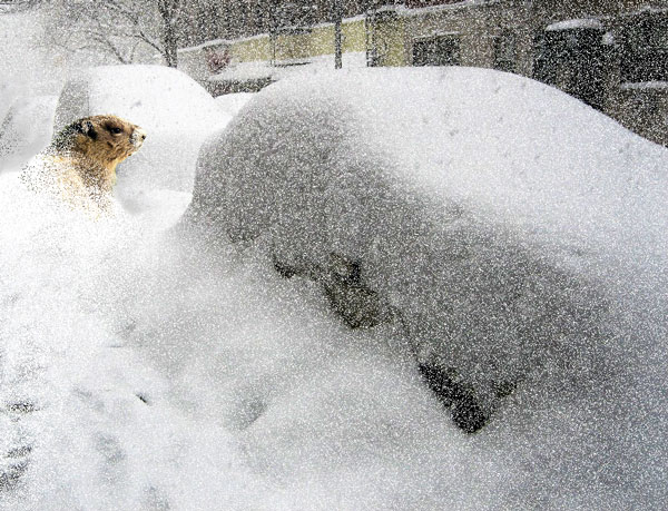
Groundhog Day ‘snowmageddon’
Administrator | Feb 02, 2011 | Comments 0

countylive.ca is working from home today. Contact us by email or through the site. The office is closed so Amber created this photo to represent the Groundhog Day 'snowmageddon'. Don't bother worrying about a giant groundhog invading downtown Picton. He's gone back into his burrow to await an early spring.
UPDATE: Prince Edward County Garbage and Recycle Collection scheduled for today (Feb 2) has been cancelled due to the weather. Garbage and recycle will be collected on Saturday, Feb. 5, 2011, for the missed Wednesday collection. Also, the landfill and transfer sites are closed today and will re-open on Saturday, Feb. 5.
In the midst of the 2011’s first “snowmagedden,” aka “snowpocolypse,” Groundhog Day predictions roll in on Facebook and Twitter from Wiarton Willie and his comrades Punxsutawney Phil in Pennsylvania, Schubenacadie Sam in Nova Scotia, Brandon Bob in Manitoba and Balzac Billy in Alberta.
Phil and Sam predict an early spring – while Environment Canada issues weather warnings and watches all over the nation – including a “dangerous” winter storm in Ontario dumping up to 30cms of snow in the southern areas. All buses are cancelled and schools in Hastings and Prince Edward County are closed today.
Phil updated his Facebook status to announce “No shadow! Early spring!” and Tweeted the same, adding “Forget science. Ignore common sense. This groundhog would never lie.”
Wiarton Willie also predicts an early spring. Poor weather caused the cancellation of special events today in Wiarton, but they are to resume tomorrow. Balzac Billy posted that “It was good to get out of that burrow but not so good to see the bright sun shiny day that greeted me. I gave the people a thumbs down and predicted six more weeks of winter. Willie and Phil are going to be much more popular than me today.”
Today is the 125th anniversary of Punxsutawney Phil’s prediction and despite the winter weather warnings, several thousand people were expected for the daybreak celebration.
Folklore has it that if the groundhogs are spooked by their shadows it means six more weeks of winter. If it’s a cloudy day spring will come early.
* * *
Groundhog Day storm’s a ‘comin’
It looks likely that every major city from Windsor to Kingston will see at least 15 cm of snow Wednesday during “The Groundhog Day Storm”, says Rob Davis, a meteorologist at The Weather Network.
“It’s almost a guarantee it’ll be more than 15 cm – it’s just a question of how much more,” he says.
Some areas could see up to 30 cm.
The first wave of the storm it to hit Tuesday, bringing just enough snow to make the workday commute a nuisance.
But that’s just an appetizer compared to the monster main course that will arrive overnight on Tuesday.
Commuters could wake up to 10 cm of snow on Wednesday, with more expected to fall throughout the morning.
The system will taper off by Wednesday evening, but don’t expect a smooth drive home, Davis cautions.
“If you made it to work, you’re going to have a bit of a rough commute getting back,” he says.
A band of freezing rain associated with the storm could graze the southernmost tip of Ontario, but most of the freezing rain will affect the northeastern United States.
The storm will push into Atlantic Canada for Thursday, leaving cold temperatures in its wake.
However the numbers play out, Davis says the storm will be one to talk about.
For more details as this storm develops, be sure to check your local forecast. You can also sign up to receive weather updates and alerts on your mobile phone.
A winter storm warning has been posted by Environment Canada
Light snow will begin in advance of the system tonight and Tuesday. However the heavier snow is forecast to begin Tuesday night and continue Wednesday morning. Potential widespread snowfall amounts of 20 to 30 cm are likely before the snow tapers off Wednesday afternoon. In addition strong and gusty east winds will develop with the snow. This will cause local whiteout conditions in blowing snow. The east winds will also generate local snow squalls off Lake Ontario in advance of the main snow area which will give enhanced snow amounts to regions near the west end of Lake Ontario. This will be the first major winter storm of the season for the Toronto area, and the most significant storm of the season for many regions outside the traditional snow belts. The heavy snowfall and blowing snow will cause whiteout conditions making for extremely hazardous driving conditions. The public should be prepared to change plans accordingly to avoid travel during the storm. This storm has the potential to create near-paralyzing conditions. Environment Canada continues to monitor this dangerous winter storm and will issue further watches and warnings as necessary.
Filed Under: Featured Articles
About the Author:


