
Thunderstorm did include lowest level tornado
Administrator | Sep 12, 2016 | Comments 0
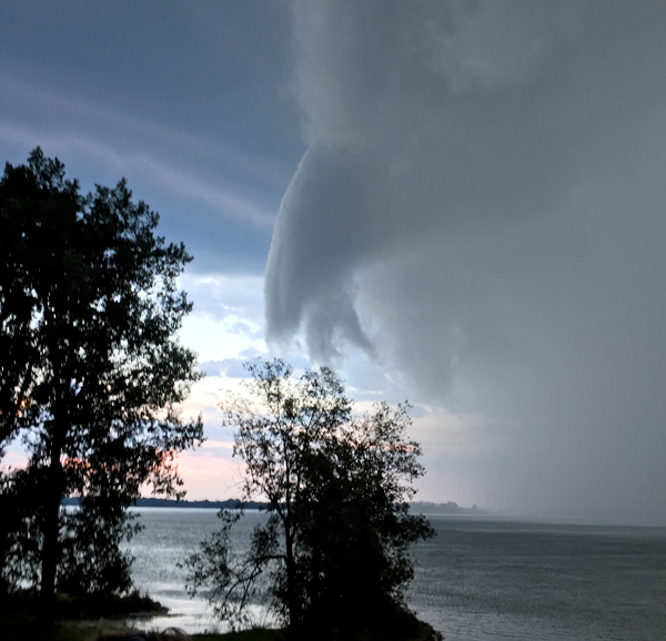
A waterspout photographed off West Lake by Rhian Halsey.
Saturday’s thunderstorm did include a tornado of the lowest possible level associated with wind up to 100km/h.
Environment Canada has confirmed an EF Zero (on scale of 0-5) waterspout came in offshore at West Lake and moved about 3.5kms
Damage in the County was mostly related to trees but most is considered “straight line damage” and not from the tornado.
An Environment Canada team visited the County Sunday to assess damage, photographs and statements that included damage to trees, 3cm hail in Wellington.
A tornado was also part of a line of thunderstorms through Wellington in 2012 when a tornado also at scale zero was reported to have touched at the intersection of Hwy 33 and Cty Rd 2.
Such waterspouts are typically not included in Environment Canada’s annual tornado tally unless they move ashore.
This was the 9th tornado of the season in Ontario, which normally sees 13 tornadoes anywhere from late April to early October.
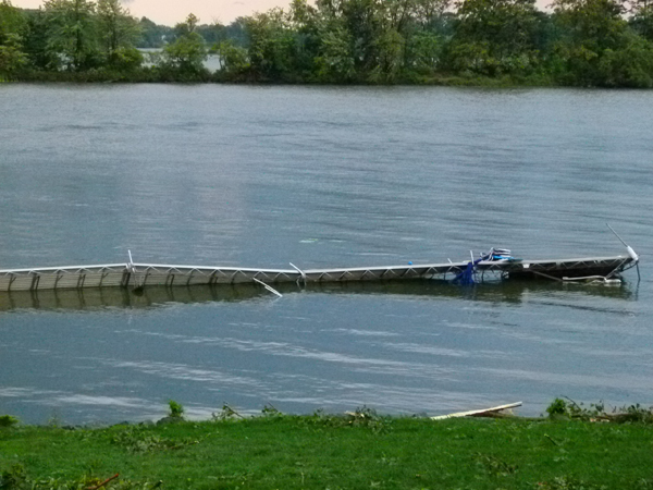
Photo by Susanne Gallant
Susanne Gallant, who lives on the waterfront at West Lake just east of Wellington, said the family’s dock and pontoon boat both took hits in Saturday’s storm.
“During Saturday evening’s storm/waterspout/tornado our canoe was also destroyed by fallen tree branches, but luckily and most importantly, we were fine and thankfully no damage was done to our home.
“With all the twisted and snapped metal framing and posts for both the dock and the boat, we can’t really see that the cost will be viable for repair. We found most of the parts, including the two full bimini’s, two doors, posts and metal framing etc in the water, which were already covered with sand and silt.
“It was actually quite an amazing sight to see the wall of waterspout/tornado speeding down the lake and then barely seeing things flying by the windows in amongst the heavy mist, and then the hail,” she said, added “we were sure glad when it was over!”
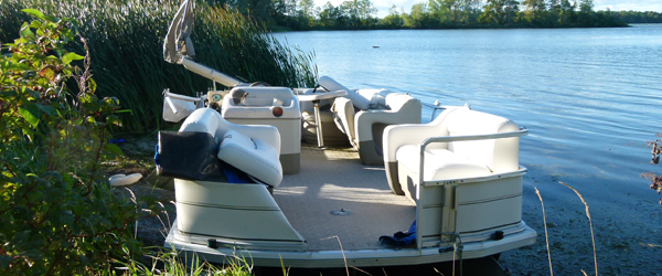
Photo by Susanne Gallant
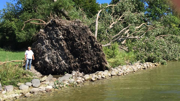
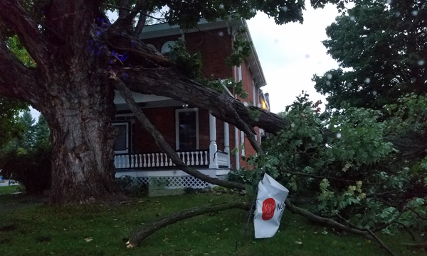
Some of the damage to a tree on a Wellington property. Nancy Parks photo
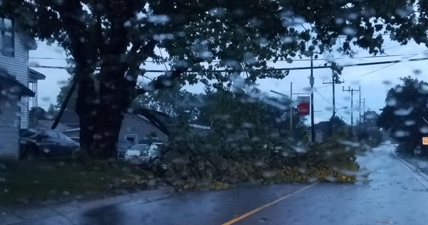
One lane blocked on Stanley Street, Bloomfield due to a fallen tree limb. Adam Miller photos
Several branches down in front of Bloomfield Main Street homes.
Clean up begins from severe storm
SEPT 11 – About 100 homes in Prince Edward County are without power following Saturday night’s storm. Hydro crews on on scenes at West Lake, Bloomfield, north of Picton and at Glenora assessing damage. At the storm’s peak, about 1,500 were without service.
Residents around the County are cleaning up debris caused by the damaging winds and intense rainfall which downed tree limbs – the most damage being reported in the Bloomfield area where power lines were also knocked down.
Environment Canada issued 17 tornado warnings and called for gusts of 100 to 120 km/h and 80 strikes of lightning per minute over Lake Ontario and Lake Erie.
A waterspout was reported over Lake Ontario at the County. Possibilities of “tornado” status in Bloomfield have not been confirmed.
SATURDAY UPDATE: 9:40 p.m. Thunderstorm warning and tornado watch ended for PEC.
UPDATE: 9:18 p.m. Tornado watch. Thunderstorm warning in effect.
UPDATE: 8:40 – PEC fire investigated a gas leak in a home in Bloomfield. Responding to reports of the smell of gas, firefighters found damage to a propane tank, and shut it off.

UPDATE: 8:19 p.m. Warning still in effect. Environment Canada meterologists have been tracking a severe thunderstorm capable of producing a tornado.
About 1,500 Hydro One customers are without power in West Lake, Bloomfield, near Picton, North and South Marysburgh areas. Hydro estimated lights should be back on by 11 p.m.
Damaging winds and intense rainfall were experienced throughout the County. Wind up to 100km/h experienced in some locations, along with intense lightning.
Firefighters, Hydro and County crews are in multiple locations tending to several calls including felled branches and hydro lines and some minor damage to homes.
Campers not able to stay at their sites are able to stay in the large lot directly across from the car wash in the industrial park at Picton. They may also stay at the King Street parking lot, Metro, Shire Hall parking lot and Mary Street Parking lot.
UPDATE: 6:15 p.m. upgraded to tornado warning
Environment Canada warns conditions are favourable into this evening for the development of severe thunderstorms which may produce tornadoes.
In this area, a ‘Tornado Watch’ has been issued for Prince Edward County, Belleville, Quinte West, Eastern Northumberland County, Cobourg, Colborne and Napanee.
Latest indications suggest increasing potential for severe thunderstorms to develop and produce isolated tornadoes as a frontal system moves through.
In the event of a tornado, or if a tornado warning is issued for your area, it is recommended you take the following actions: Go indoors to a room on the lowest floor, away from outside walls and windows – such as a basement, bathroom, stairwell or interior closet.
Leave mobile homes, vehicles, tents, trailers and other temporary or free-standing shelter, and move to a strong building if you can. As a last resort, lie in a low spot and protect your head from flying debris.
Tornado watches are issued when atmospheric conditions are favourable for the development of thunderstorms that could produce tornadoes.
Filed Under: Featured Articles • Local News
About the Author: