

Staff recommend denying 400-unit Sandy Hook sub-division; council seeks talks
Administrator | Jul 21, 2024 | Comments 9
By Sharon Harrison
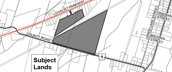
A proposed substantial residential sub-division, known as Loyalist Heights, offering a mix of 396 new dwelling units on a parcel of land located between Sandy Hook Road (County Road 1) and Loyalist Parkway, has been referred back to municipal staff.
At last week’s planning and development committee meeting council (10 members only, with councillors Prinzen, Pennell and Maynard absent and Nieman excused due to pecuniary interest) voted to send the file back to staff for further discussion with the developer in an attempt to resolve numerous issues raised by staff, who had recommended the application by denied.
“We have mentioned on a number of occasions to change things and it’s just been entrenched, we are not doing anything, and the discussions have stopped,” said Michael Michaud, manager of planning. “They don’t want to discuss anymore, they don’t want to move forward, and for the most part, they have just been reticent in, ‘this is what we submitted, please approve it’.”
An application for an official plan amendment, plan of sub-division and zoning bylaw amendment submitted by the applicant, 1983358 Ontario Inc. (owner Mr. Narisu Huhe) proposes to develop the site at 13437 Loyalist Parkway in Picton into a residential plan of sub-division.
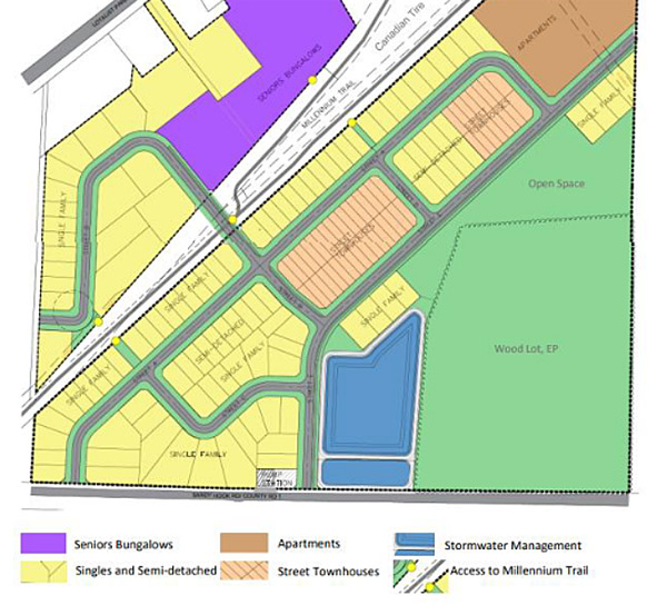
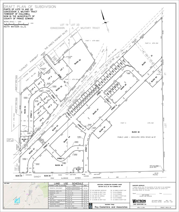
 The applicant is looking to sub-divide the 25.8 hectare parcel of land, which straddles the Millennium Trail, into 100 single detached residential lots, 26 semi-detached dwellings, 47 townhouse units, 193 apartments, and a senior’s village consisting of 30 bungalows.
This fourth application revision submitted by the applicant, was “denied on two out of three counts, resulting in the denial recommendation by staff” said Matt Coffey, planning approvals co-ordinator, who said the proposed layout of the development does not result in the highest and best use of the site, and does not result in good planning.
The planning department cited various reasons in the recommendation to deny the application, including inadequate (low) density, insufficient parkland dedication, and how the configuration of proposed homes would adversely interact with the Millennium Trail and not be incorporated in the development.
“We started this process three years ago and we are finding that things are changing as we go, so we are not always in sync, and we are not always understanding what staff are trying to achieve, and that’s part of the issue we are trying to achieve,” said agent for the applicant, Ray Essiambre, with Ray Essiambre and Associates.
“We do not accept the staff recommendations. There is not enough information to be able to refuse the applications,” he said.
Comments were heard from seven members of the public, including the Waring’s Creek Improvement Association and the Prince Edward County Field Naturalists, as well as from Essiambre, the applicant, council members and planning staff.
Comments from the public included concerns surrounding displacement of wildlife, removal of trees, soil erosion, development on prime agricultural land, increased traffic concerns, property lines, potential contamination of water supply, insufficient infrastructure and detrimental quality of life, among them.
“This land acts as a wildlife corridor to Waring’s Creek headwaters, which is a protected wetland,” said Kimberly MacDougall, who, along with several others, spoke to the destruction of farmland to development, particularly prime agricultural farmland (while many locals recognize the site as prime ag. land, it is no longer officially designated so). “This is a very sad and hopeless conclusion for so many to come to.“
Cheryl O’Brien spoke on behalf of the Waring’s Creek Improvement Association (WCIA) and provided a brief history of the creek, and the mandate of the association as far as rehabilitation and preservation of the creek goes. She noted that Waring’s Creek is identified as a cold-water stream in the County, explaining how the creek and the headwaters function.
She noted the level of current development applications and cumulative impacts of the developments “will tax the function of this environmentally-sensitive area”. She said the WCIA is requesting a review to improve the protection that is currently in place.
“Paving paradise will impede the ability of water to filter through and replenish the water system,” said O’Brien, adding many rely on wells in the area.
Amy Bodman and Gerry Jenkison spoke on behalf of the Prince Edward County Field Naturalists where Bodman noted how Waring’s Creek is the largest cold water creek in Prince Edward County and supplies ground-water to some of the most fertile and productive agricultural lands here.
She pointed out it is an essential part of the natural heritage system, where the entire watershed covers 17 square kilometres.
“The Loyalist Heights development is proposed to be built on land that includes the headwaters of Waring’s Creek. The woods and wetlands on the development site are part of a re-charge system that releases water through upwellings into Waring’s Creek, which in turn eventually reaches as far as the Beaver Meadow wildlife area,” Bodman said.
She also addressed the impact this and further developments will have on Sandy Hook Road.
“This may be one application now, but the cumulative impact of it alongside other developments presently in the planning stages, needs to be considered when our official plan emphasizes the need to protect the Waring’s Creek sub-watershed.”
She stated 396 units proposed for Loyalist Heights could add 500 cars to the road, not to mention delivery and service trucks, etc. servicing the development, on Sandy Hook Road which is already used as a Picton bypass by many.
“Cold Creek sub-division has a proposed build-out of 904 units, Base31 is planning to build 350 units in 2025 (and up to 7,500 in the next 25 years), Vineridge development (next to Macaulay Mountain) is planning to build 432 units,” Bodman reminded.
“Added together, these four developments alone represent 9,229 units, probably more than 14,000 cars, and these are only the developments we know about. Add to the fact the County is very seriously considering turning Sandy Hook Road into a truck bypass in its traffic master plan.”
Kensey Best, spoke as a mother of a sixth generation farmer, about the proposed 300 homes to be built on some of the County’s best farmland.
“You ask any farmer in this community and they will say that land is prime ag., not a person sitting at a desk, any farmer. Because it is not deemed ag. one, does common sense get thrown out the window?” asked Best.
“This land is the best land in Prince Edward County; it is land you can dig 50-feet down and not touch a rock, it has incredible drainage, rich topsoil and a high water table – it is rare. It is unfortunately ideal and superb for developers as it is ideal when you are digging and building trenches,” she continued.
“We should be planting crops, not homes, on our prime one ag. land. God is not making any more land; once it’s gone, it is gone. Once there is no land left, you will then learn that you cannot eat money.”
 Coffey went into further detail on the five key areas of concern and the reasons for the recommended denial for the application, saying, “we have provided a number of comments back to the applicant on this design”.
He said lots should not be backing onto the Millennium Trail.
“There is an opportunity to re-align the trail just to the east of the site, but that has not been pursued by the applicant.“ He said the opportunity to re-align the trail would save the municipality significant money on maintenance over the long-term, and would provide some additional lands to the seniors’ village.
“As the County becomes more developed, we are seeing impacts on the trail, and we are going to see impacts on the trail, particularly in Wellington and in Picton, so we need to give some thought on how this trail is going to function as our community develops,” added Coffey. “Being a former railway, these lands were not intended to blend with residential areas.”
Coffey’s issue with the large lots was explained.
“Lots 1-9 are located in a pocket just north of the Millennium Trail and these lots are fairly large in area and do not meet the density requirements of the secondary plan,” he said. “There are nine units on two acres and this is far below what the secondary plan recommends in terms of minimum density.”
Essiambre countered.
“We are slightly above the target density (at 25 units/hectare per the secondary plan), so I don’t know why the staff are saying we are below the acceptable density for this area. We are actually over it slightly,” said Essiambre.
Essiambre said there is a reason for large lots and “it isn’t always about density”. “We have already achieved the target density for the secondary plan, and so we have some capacity to create some larger lots for a very specific reason which has to do with compatibility of the adjacent uses south of Loyalist Parkway.“
He said, the reason for the large lots is to recognize the natural heritage on the site and incorporate that into the development, “we have the capacity, we are over density”, he reiterated.
Designated as town residential area under the Picton urban centre secondary plan, the development would have provided an average residential net density of 29 units per net hectare, contrary to the plan’s preferred target of 25 units per net hectare, according to Coffey.
He noted in his presentation, the development “is the headwaters of Waring’s Creek, which is designated as environmentally protected on the secondary plan”.
The proposed development is to include 50 affordable units (one and two-bedrooms), comprising 25 units to be rent-to-own, and 25 units to be sold at CMHC (Canada Mortgage and Housing Corporation) affordability limit, with the 50 units to be allocated and administered by the County, according to Essiambre.
Coffey also had issue with an insufficient parkland design.
“We have parkland that is split between two locations, that is not an ideal parkland configuration and should be all merged and is easily accessible for everyone who lives in the community,“ Coffey said.
Speaking to the request for the applicant to expand the proposed sub-division and consume part of the trail, Essiambre explained how staff want the applicant to purchase that section of the trail.
“The problem with the trail is the adjacent land owner does not want to buy the trail”, where he notes the trail has not been declared surplus by the County.
Councillor Kate MacNaughton noted how there has not been discussion about the trail in an urban landscape and what that means.
“I don’t think we have understood what the community vision for that is and whether a much more urbanized Millennium Trail landscape is going to be supported by the community,” MacNaughton said.
Essiambre also spoke to the shape of the proposed park, where he noted the plan showing open space is out of date, where he said revised drawings were filed in May.
“The area (1.3 hectares), the issue with that is the shape of the park, according to staff, is problematic: we can’t make a square out of a triangle,” said Essaimbre, adding that the only thing they can do is move the park.
“The implication is that the area adjacent to the environmental protection area will become residential which is not the most desirable thing as we are trying to keep all the public lands together.”
“Although the development meets the preferred density (when averaged) across the development, the lands north of the trail propose large residential lots which result in a low-density in this portion of the site,” stated Coffey. “This does not result in the highest and best use of land, and is not ideal for the extension of municipal services.”
He said the road pattern is inefficient and results in a density level on the northern portion of the site that is too low and creates large lots (1,200-4,500 square metres), “that are not conducive to optimal utilization of municipal services”.
He said staff have repeatedly requested that the lots backing onto the Millennium Trail be re-aligned so that the street is adjacent to the trail, noting recently approved developments in both Picton and Wellington have incorporated the trail into the development and into the proposed road network, where possible.
“Back-lotting onto the trail is to be avoided in order to incorporate CPTED (crime prevention through environmental design) principles on public areas and to promote the trail as an active transportation link and a multi-use route within new communities,” he said. “Without the inclusion of the trail into the development, the street network and lot fabric cannot be supported by staff.”
The re-zoning application would have changed the zone from rural zones to incorporate a series of special urban residential zones.
“The purpose of the official plan amendment would re-designate the lands currently designated as Service Area 3 (limited municipal services) with the re-designation to recognize the site to be within Service Area 1 (full municipal services).”
Coffey’s report states how low-density residential development is the predominant land use along Loyalist Parkway, whereas the adjacent lands to the east are vacant and are the site of separate development applications.
The proposed development is comprised of two separate parcels that are divided by the Millennium Trail. At this location, the trail separates into a northern leg which crosses Loyalist Parkway near the Canadian Tire site, notes the report.
“The site is split by the Millennium Trail which runs right through the centre of it, it splits the property into a northern half and a southern half.”
“Being a former rail line, this split was created as the sections of track split north toward Picton Harbour and east toward Lake Street. The result is a separation of the development that increases as the northern leg of the trail extends north.”
He said, a narrow strip of land between the two trail legs forms part of the Canadian Tire site. Although, this type of configuration was necessary to facilitate a railway, as a recreational trail it can be re-configured to provide shorter and direct routes providing a better use of land.
The parcel north of the trail would be developed into single detached homes, and the seniors’ village with this section of the development to be accessed through the development by Street C crossing the Millennium Trail.
South of the trail would contain single detached dwellings, semi-detached homes, a series of blocks for townhouse development and an apartment block. Future public lands would be included on Block 44 would contain a stormwater facility, parkland facilities, and an environmental area associated with the existing woodland.
Coffey further noted in his report how staff have facilitated discussions between the owners and the Canadian Tire Corporation, where he said the purpose of the discussions were for re-aligning the Millennium Trail and incorporating additional lands into the development.
“The result of a re-alignment would benefit the municipality by removing several metres of recreational trail which would be accommodated through a T-intersection rather than the gradual merger that exists today,” he states. “The re-alignment would also benefit the development by increasing the developable land area and increasing unit counts.”
”Through these discussions, there was a willingness from Canadian Tire representatives to consider selling their portion of these lands,” he added.
Coffey indicates that as part of the response to staff comments, the applicant has indicated that a single-loaded road will have financial implications for the municipality.
“As the trail becomes more urbanized, proper design (such as incorporating the trail into the transportation) network would encourage active transportation from the development to destinations within the town,” he said.
”This would be accomplished by enhancing the existing infrastructure and providing opportunities for improvements while reducing the need to include sidewalks or bike lanes along the proposed streets. It would also permit the opportunity for less road width reducing the amount of hard surfacing required.”
He notes how this approach has been demonstrated in another local sub-division, as well as being presented in recent other sub-division concepts in the County.
The decision to refer the application is expected to be ratified at next Tuesday’s council meeting.
All planning documents related to this application can be found on the County’s website.
Background stories can be found here:
Information meeting set for Loyalist Heights development applications
Filed Under: Featured Articles
About the Author:


From the coverage, I take it that:
1) Staff have recommended denying the application multiple times; and
2) Council have said “keep talking to the developer”, and
3) The developer says “not interested in talking, approve what we submitted”.
Council is still embracing the fantasy spun for them by developers (and Staff in the recent past) that hordes of people are beating a path to the County to live. The real numbers do not support that notion, but made-up forecasts and spreadsheets are used to push development over the objections of taxpayers.
Next move will be for the Ford government to bulldoze in and support the developers under the guise of “Build More Homes Faster”. The County (and much of Ontario) voted for them, now we will have to live with the results.
There would not need to be such a push to increase the tax base if it were not for the spending bloat of Staff. Stay tuned for the coming Audited Financial Statements for the year ended Dec 31, 2023.
I am encouraged by the staff to remain resolute on these issues. Support from the community is extremely important to demonstrate we are here, we are listening, we are watching and taking notes. We are not to be underestimated. Thank you all!
If there wasn’t a desire for needed housing, developers would not be coming forward. This is a well thought out proposal that protects Warrings Creek and is line with Urban Sprawl growth. We need this housing, more residential tax dollars and most certainly more connections to our water system. This I view as a positive move for the County.
The simple fact remains, this is Prime Agriculture and shouldn’t be built on. There are many pieces of land more suitable for a development. Our Council should be protecting this land.
Please protect the natural buffer along the Millennium Trial. Agree “The trail needs a wider buffer for wildlife”, or at least the illusion of one. Also to embrace the “Rail” Heritage of the cross County Trail (not erase) enhances County culture & tourism dollars. Development Fees collected at time of building provide infrastructure & services but profit motives logically outweigh Heritage, Nature, & Culture. Applaud & thank PEC Councillors & Municipal staff for efforts and listening to protect quality of life. Now’s the time before we “pave paradise” !!!
Thanks so much for the detailed report on this topic. It saves all of us from having to watch an hour (or whatever) of video.
When I’m researching something municipal from the past, CountyLive is my #1 resource because of well written reports such as this one. Thanks again.
Exactly!! What is the big push for more and more housing and where are these residents going to work? Who can afford the rent or a mortgage working at a fast food joint or part -time hourly job?
Is this council’s attempt to increase the tax base? Perhaps the plan should be to establish a job market here in the County before going all out on the building craze. I’m surprised developers are even interested in building here if there won’t be a working population here to reside and work. Yes, seniors will need a portion of this housing if they can afford it, but that’s a risk.
When will this madness stop.
Good opportunity for council to take a breather on development. Give this land back to farmers and nature. The trail needs a wider buffer for wildlife, the stretch fro CR4 to Loyalist currently has dozers 15 feet from the trail, bird and wildlife are being flushed out… super sad and no longer a nice feature for walking or biking.