

Association shares concern construction will destroy Waring’s Creek
Administrator | Jan 19, 2025 | Comments 0

It was a packed house at the Waring Hall for a community event hosted by the Waring’s Creek Improvement Association
By Sharon Harrison
“We might destroy Waring’s Creek just in the construction phase,” stated Les Stanfield, a stream and landscape ecologist, referring to the two large proposed development projects poised for the sensitive agricultural lands along Sandy Hook Road, which form part of the Waring’s Creek watershed.
“Thirty-two years of restoration work on Waring’s Creek will be reversed in less than a year; we will not recognize the stream in three to five years,” he predicted.
The proposed Cold Creek sub-division is expected to bring 905 homes, the adjacent proposed Loyalist Heights sub-division another 495 dwellings, for a total of approximately 1,400 new homes. Both proposed developments border Sandy Hook Road in Picton, and both are located within the Waring’s Creek watershed.
And as Stanfield points out, the larger West Meadows development, just across Loyalist Parkway off George Wright Boulevard, also has effects on the Waring’s Creek watershed, its cumulative impacts not even considered, he said.
Waring’s Creek is the only cold-water creek in Prince Edward County, described as an underground lake, it is a special watercourse of great significance. The creek is 17.3 square kilometres with its main channel starting behind the Picton LCBO and travels all the way down the watershed to West Lake.
A lake historically, it had a great big glacier overtop, described Stanfield who spoke to the geology of Waring’s Creek and why it is so special. “The beautiful thing about Waring’s Creek is that it is a glacial channel.” He explained how the limestone bedrock tilts toward the south-west from Picton to West Lake, but also how the soil is porous (sand and gravels) and are intimately connected.
The Waring’s Creek sub-watershed is listed as a significant natural heritage feature with special protections in both the official plan and the Picton secondary plan. It is also identified in the official plan as part of the largest significant groundwater re-charge area in the County.
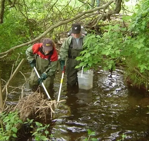
Over the past 32 years, the community advocacy group, the Waring’s Creek Improvement Association (WCIA), has been caring for, preserving and restoring the creek. There are 109 private well owners who draw water from Waring’s Creek.
“This land some years ago was changed from agricultural to future development, and we believe that should never have happened, and we now have to live with the consequences of that,” said the WCIA’s Cliff Rice.
Furthermore, it was noted the municipality has failed to uphold its end of the 2007 Minutes of Settlement Agreement with the WCIA, intended to provide protections for the creek and the watershed.
“Up until a few weeks ago, planning staff denied even seeing the document, so it was never taken into consideration when the County was considering these approvals,” said Rice. “We really believe that at the time, these applications should never have been received until the work that was promised by the County had been performed.”
He noted the planning department actually recommended approval of both sub-division applications to council, in spite of the fact that no hydrogeological study or cumulative impact studies have been done.
This is not the first fight the WCIA has found themselves dealing with as the signed 2007 agreement came about when a water main extension was proposed to run beside the Waring House, along with a sewage pumping station and a sewage water line running the length of County Road 1, said the WCIA’s Cheryl O’Brien.
“These things have a real propensity to leakage and the water in this area is very high to the ground level, so to dig these sewer lines they would have to go into the water table and any leakage that would occur would have a direct effect on wells, the creek, agriculture in the area, etc.” she said.
At the time, the WCIA applied to the Ministry of Environment for a Minutes of Settlement, a document signed in 2008 by then County mayor Leo Finnegan and WCIA’s Cliff Rice.
“In that, there were no pumping stations or sewer lines involved after that, and their and our lawyer and planner worked with the County’s planners to put in place into the new secondary plan, and further on into the official plan, certain protections for the creek and watershed as a whole,” outlined O’Brien.
 With the current proposed housing developments to include sewage pumping stations and sewer lines going into the headwaters, she said WCIA are currently in exactly the same place they were in 2008.
“We are really looking for the County to help us move this forward, so that regardless of what goes on in that area, that watershed will be protected, the water will be protected, the creek will be protected, our wells will be projected, the farm water sources will be protected, and so that’s what the minutes of settlement and this agreement with the County is all about.”
It was a packed house at the Waring Hall (hall rental donated by the Waring House) Wednesday evening for a special community event hosted by the WCIA.
The informal social occasion included a series of slideshow presentations and speakers who spoke about the creek’s history and background and the extensive amount of work the group has done over 32 years (and are still doing) with information, facts and figures.
Questions from members of the public were received throughout the presentations, as well as at the end of the meeting.
Local farmer Dan Langridge, operates a 25-acre market garden on Sandy Hook Road, got to the nuts and bolts of the issue of messing with a sensitive underground lake, armed with detailed figures and speaking also to what development means to resources and the watershed.
“It’s an underground lake, plain and simple,” said Langridge.
Langridge ran off a lot of numbers and detailed technical information, also sharing his intimate knowledge of the land he has worked and farmed for many years (including the lands of both proposed sub-divisions).
Of his 45 years of growing, 27 of those have been on Sandy Hook Road. Langridge has worked in industry for decades, dealing with sewage treatment pumps and stormwater ponds. He has also captured the niche market of growing giant pumpkins for 17 years because the plentiful water on his farm makes it easy to do so – the thirsty pumpkins consume about 200 gallons of water a day.
“It’s all about water; this whole watershed depends on water and is based on water, and it’s a really complicated watershed,” said Rice. “There is a ton of water in this watershed and that’s what keeps this creek flowing, and keeps it healthy.”
So much water and so many proposed homes (maybe with underground parking lots too) don’t mix, where Langridge spoke to how close the water table really is to the surface and the impact of the proposed sub-divisions to the land and the watercourse.
When agricultural and treed land is developed, the water (rainfall and snowfall) that is usually easily absorbed into the ground in a natural environment, and is sucked up by trees and vegetation, suddenly has nowhere to go, except travel across the new concrete ground, gravity naturally taking it to the lowest point.
Therefore, when new sub-divisions are proposed, they will often include a stormwater management pond. Basically, all surface water is channelled into the storm water pond, excess surface water is avoided and is managed by staggered release, according to the situation.
In this case, because the proposed developments are sitting atop and beside a large underground lake, and where the water table sits very close to the surface, several local experts, including Langridge, indicate the stormwater management ponds won’t work and will frequently overflow because of the amount of water they will be required to handle.
Langridge explained that for the proposed Loyalist Heights development of 75.17 acres, there is going to be 30 acres of building (streets, sidewalks, houses, etc).
“Instead of having the whole 75 acres, as we do right now to infiltrate the water, the water is going to come to the stormwater sewer and it’s going to overflow, and we are a few metres from Waring’s Creek,” Langridge explained. “Every inch of rain we receive at Loyalist Heights, there is 650,000 imperial gallons that is going to be discharged at the headwaters. That is from just one inch of rain.“
The adjacent proposed Cold Creek development is 86.45 acres, where he says the same thing applies as with Loyalist Heights, where Langridge shares the figure of 743,000 imperial gallons from Cold Creek (with just one inch of rain).
He said these numbers are on top of another section of property in the area draining, bringing 361,000 imperial gallons into the stormwater management pond.
Langridge stated the developers are relying on evaporation, so water will be sitting, until it evaporates.
“The main concern is, once we overfill the stormwater ponds, everybody knows oil, water, any contaminants (from driveways, streets, etc.), is going on the surface, it’s going to overflow into Waring’s Creek, and that’s a concern.”
All this adds up to a run-off increase of 396 per cent, he said, with over 103 million gallons of water overflowing into the headwaters, for all three properties.
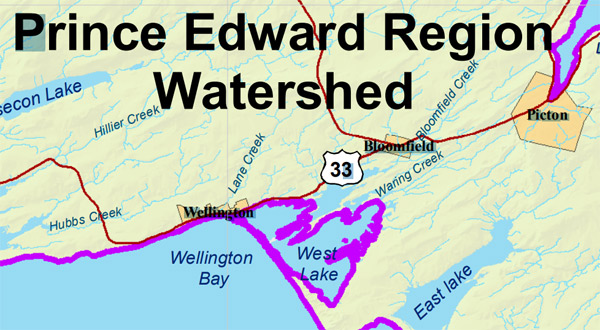
Portion of a Quinte Conservation map showing the location of Waring’s Creek
Another point Langridge made is the problem of a climate and environment that is changing faster than the data is being changed, meaning it’s no longer valid.
Stanfield said a 400 per cent increase in flows is unheard of, “it is unbelievable”, and a “38 per cent decrease in groundwater input and infiltration, 38 per cent less water to your wells, the groundwater table will be seriously impacted”.
Langridge said the thing to look at is de-watering (a process of removing surface or ground water from a particular site).
“The bottom line is, if you are going to start putting in sewage lines and everything else in here, and you want deep water so you can do that, how do you de-water an underground lake, and where’s that water going, where do you pump the water to, and what is the affect on the wells?”
He explained that there is no way to calculate how much water is there when you go down three or four feet, where he said he can’t run the numbers because he doesn’t know how much water is there.
Rice said his most immediate concern is the de-watering.
“If they are going to have an increase of 400 per cent in flows in the long-run, how much of an increase are they going to have when they try to de-water that lake,” said Rice. “We might destroy Waring’s Creek just in the construction phase. There is a lot of smoke and mirrors.”
Stanfield also touched on the cumulative impacts of the proposed developments to Waring’s Creek, including “urban stream syndrome” (basically cess pools), something that happens when increased flows happen to streams, known as “flashy streams”.
“What happens when you increase flows to a stream, the flows get constricted through a short time span, and it basically flushes the stream. As you urbanize an area, you create these flashy peak-based streams, they have a terrible effect on the stream. Terrible.”
He said, they cause down-cutting, widening, erosion, siltation, increased sediment flows, and worse than that, it has a cascading effect, so increased erosion creates more sediment, and more sediment creates more erosion, and on and on it goes.
“It becomes this urban stream syndrome, it is a horrible effect on the stream. It has a huge effect on the ecology of the stream and it’s perpetual: it takes thousands of years to restore the river once you do this to it because it has to find a new balance.”
Stanfield said it gets worse.
“We have no baseline data, they have no idea what the flow rate is at Waring’s Creek, they have no idea what the well rates are, they have no idea what the water quality is, they haven’t even done any water quality testing. We don’t even know what the nitrate levels are, we are very concerned.”
“The County is finally opening its eyes and ears to a cumulative effects study. The main point is that it should work towards a no-loss or improved ecological integrity, not gradual declines as has been the mandate,” said Stanfield.
For more information about the Waring’s Creek Improvement Association’s work, and to donate to help fund 50 per cent of the cost of undertaking a hydrogeological study (anticipated full cost $25,000 to $50,000), visit the WCIA website
Loyalist Heights sub-division to be deferred for groundwater impact study
Filed Under: Featured Articles • Local News
About the Author: