
Loyalist Heights sub-division to be deferred for groundwater impact study
Administrator | Dec 12, 2024 | Comments 0
By Sharon Harrison
The fifth revision for an application for the proposed (now 495-unit) Loyalist Heights sub-division off Sandy Hook Road was deferred at Wednesday’s planning and development committee meeting. That decision will move to council to be ratified.
Councillor Sam Branderhorst brought forward the deferral motion so a cumulative hydrogeological (study of groundwater) impact study can be prepared by a third party – at the cost of the applicant – and in consultation with the Waring’s Creek Improvement Association (WCIA) and the municipality.
The intent of the study is to determine the cumulative effects of both proposed developments (Loyalist Heights and the adjacent Cold Creek), where Michael Michaud, the County’s planning manager confirmed the cumulative impact study would be a peer review of existing documents.
“We are not going out to gather new data, it is simply taking information we have and making sure they speak to one another,” said Michaud.
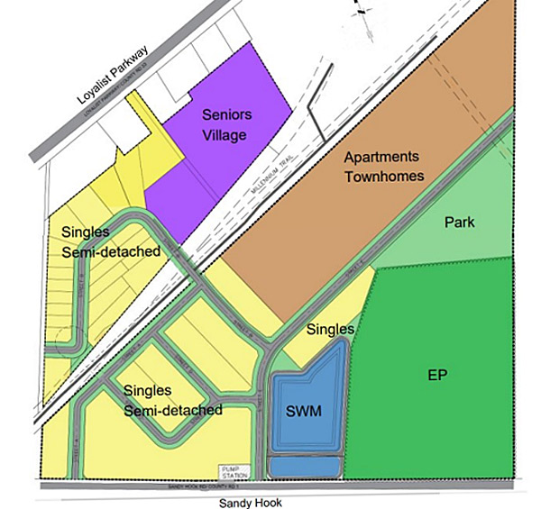
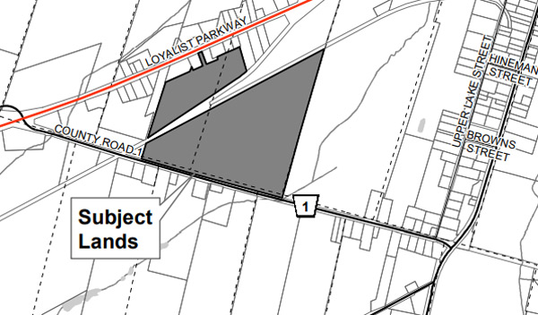
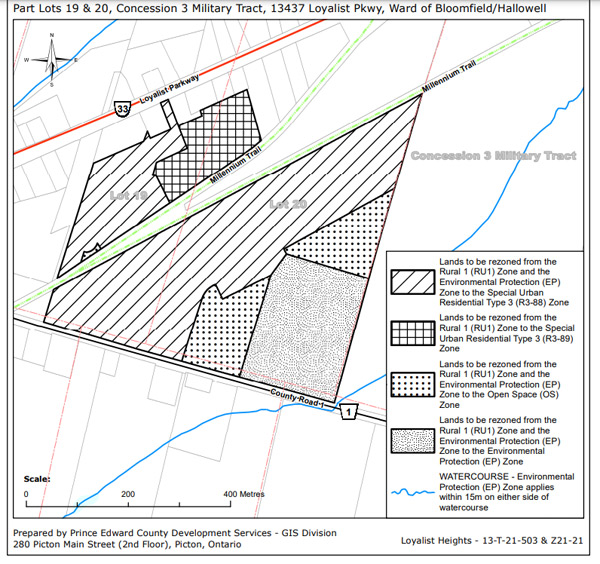
The applicant, 1983358 Ontario Inc. (Mr. Narisu Huhe), has filed an application for an official plan amendment, plan of sub-division and zoning bylaw amendment to develop the 25.8 hectare site located at 13437 Loyalist Parkway, Picton (with frontage along Sandy Hook Road and Loyalist Parkway) into a residential sub-division.
The proposed development is comprised of two separate parcels that are divided by the Millennium Trail. The planning department’s Matt Coffey notes the narrow strip of land between the two trail legs forms part of the Canadian Tire site.
While planning staff had recommended in July the application be denied (as they were still dissatisfied a number of criteria had not been met), council once again asked staff to attempt to converse with the developer after discussions stopped.
In this latest fifth revised application, staff’s recommendation has changed to now to approve the three applications (zoning amendment, plan of sub-division and official plan amendment). It was noted that the sticking points raised in the planning meeting of June 19 have been resolved, according to planning. Background story here: https://www.countylive.ca/staff-recommend-denying-400-unit-sandy-hook-sub-division-council-seeks-talks/
The proposed Loyalist Heights development would bring a varied mix of accommodations, from townhouses, to single detached and semi-detached homes, an apartment block, as well as s seniors’ village. Affordable housing units have increased from 50 units to 75.
These latest changes will see overall density increase by 99 units (from 396 residential units to 495), bringing net density for the development up to 36 units per net hectare (from 25 units per net hectare), and is consistent with the secondary plan – planning staff had previously noted density was too low.
A brief summary was provided by Coffey, who stated the latest changes are based on feedback received at the last meeting, where the applicant has amended the road configuration, although the primary access remains unchanged (with two proposed entrances off Sandy Hook Road and a future connection to lands to the east), and has improved the parkland dedication
“The parkland dedication is in a much more appropriate location and creates a block that can be merged with the development to the east [Cold Creek], should that development be approved as well,” said Coffey, adding that the environmentally-protected lands will be dedicated to the municipality.
“Back in June, staff had a number of comments on the previous version of the plan, and so this particular version has proposed fewer residential lots backing onto the Millennium Trail which had been a concern of ours,” he said. “They are now proposing a window street along the trail in the south-western corner.”
Coffey said there remains an opportunity to re-align the trail and to merge lands with the Canadian Tire property to the north.
“In summary of some of the public comments we heard, there are concerns about Waring’s Creek and the impacts of the watershed; there are concerns about environmental impacts, not just on the site itself, but cumulative when different developments are combined with each other,” he added.
He said concerns such as a lack of low-impact development (LID) features being proposed, impacts to the Millennium Trail, increases in traffic, and impacts or the loss of agricultural land, have been addressed.
“The sub-division proposes a mix of residential typologies which represent good planning: their particular design incorporates the Millennium Trail and there is an adequate level of parkland dedication which is strategically located and it represents good planning.”
Low-impact development (LID) is a stormwater management strategy that seeks to mitigate the impacts of increased run-off and stormwater pollution. LID measures that work with nature to manage stormwater as close to its source as possible include: infiltration islands in parking areas, use of permeable pavements, green roofs, bio-filtration swales, rain gardens, cisterns and rain barrels, and compact development.
Ray Essiambre, agent for the applicant, noted a number of changes to the proposal, highlighting three key design changes, noting greater consideration of Waring’s Creek and the Millennium Trail in the current proposal. He also said there are no longer any rear lot lines backing onto the trail saying the design is now a trail-oriented development.
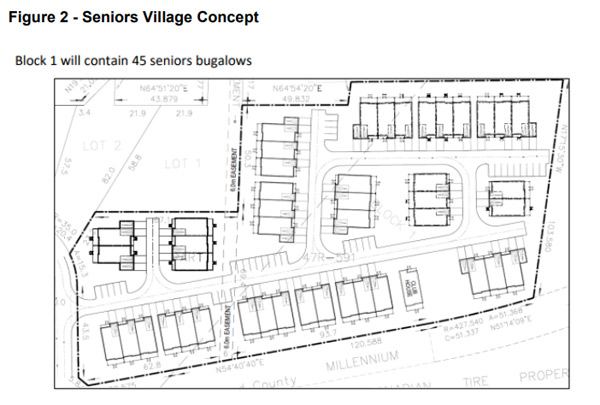
“Densities have been increased and the primary location where the density will be an expansion of the apartment block to accommodate 96 townhouses and 254 apartments. The seniors’ development has been increased from 30 to 45 units.”
He said, a park has been reviewed in terms of its location and size and is deemed to be an appropriate size and of an appropriate location, and has been increased in size from 1.3 hectares to 1.7 hectares (now 6.5 per cent coverage – five per cent is minimum). “It is integrated within the park for Cold Creek, so ultimately there will be one larger park combined into two.”
Addressing LID, Essaimbre said, “Our stormwater management report addresses that in detail, but basically, it’s the use of larger infiltration basin at the outlet of the stormwater facility…” , where he suggested residents use rain barrels and gardens.
“The greater consideration of Waring’s Creek, the development in Loyalist is set back 200 metres from Waring’s Creek, the public-owned land, the park, stormwater pond, and the EP area combined provide greater protection to Waring’s Creek.”
Eleven people spoke during the public comments section, many of whom have expressed concern to the issues on previous occasions, and several of whom are expert in their field, and these included the PEC Trails Committee, the Prince Edward County Field Naturalists, along with the Waring’s Creek Improvement Association.
With the protection of the creek at the forefront for many, other issues of concern raised included the street crossing the Millennium Trail, flooding due to increases urbanization, traffic increase, unmanageable congestion, endangering wildlife, and the on-going surface water problems.
Dr. Cliff Rice, WCIA president, reminded that one of their major considerations and objections on the proposal, and adjacent lands, is the water.
“How water is handled by this development and the adjacent one will literally determine the life or death of Waring’s Creek, which is the only cold water stream in Prince Edward County.”
Rice asked that a condition be put on the proposal that no work commence until a comprehensive peer review hydrogeological study is completed, and any implications that may arise, are addressed. He also offered the opportunity to the County to partner with WCIA in order to complete the studies.
“The rationale behind this is, we do not think we have enough hydrogeological information to safely proceed with this proposal,” said Rice, who also reminded that the “negotiated settlement between the WCIA and the County in 2008 mandated that the County was responsible to map the watershed and perform the appropriate studies before any development occurred”.
“A comprehensive hydrogeological assessment of the entire property, including cumulative impact studies, would have confirmed whether this land was even developable, and if so, what the appropriate parameters for these developments would be,” he said. “The County has failed to meet their obligation under the agreement and we consider the County to be in breach of contract.”
Representing the Prince Edward County Field Naturalists (PECFN), Gerry Jenkison expressed concerns that the proposed development includes no low-impact development or green design features.
“We noted the specific implementation policy in the Picton urban centre secondary plan calling for LID in the Waring’s Creek watershed, and for consistency, with the green design initiatives discussed elsewhere in the secondary plan,” said Jenkison.
“No LID measures have been proposed in the current iteration of the applicant’s planning justification report. None of the green design initiatives noted in our comment have been included.”
Also with PECFN, Amy Bodman was looking for greater consideration for Waring’s Creek -the entire sub-watershed covers an area of 17-square kilometers- indicating many issues have not been adequately addressed since the last meeting.
“Waring’s Creek is a defining feature of Waring’s Creek sub-watershed which supplies clean, cold groundwater to many, many homes, and to some of the most fertile, and productive agricultural lands in the County,” said Bodman. “The Waring’s Creek sub-watershed is identified as the County‘s largest significant groundwater recharge area in the official plan, and as an essential part of our natural heritage system.”
The applicant’s EIS (environmental impact study) fails to mention either of these facts, she said.
“In both the Picton secondary plan and the official plan, the County has created special policies to protect the Waring’s Creek sub-watershed,” explained Bodman. “In our official plan, all tributaries and wetlands associated with the watershed are afforded the same special protections as the creek itself.”
“The applicant has not given greater consideration for Waring’s Creek, nothing new is being brought to the committee for consideration,” she added.
Dan Langridge brought some extensive and important technical calculations (details unfortunately only available to council at this time), where among his credentials, he said he has worked on wet well sewage pumping stations, in-ground cement water retainers and stormwater management ponds.
Langridge spoke to permeability reduction, drawdown and the function of stormwater management, basically examining how much rain it will take to fill the stormwater pond the first time to overflowing.
“The environment is changing faster than we can collect the data and is no longer meaningful,” said Langridge. “The bottom line is, LIDs won’t work in this property because for every millimetre of rain received, 38.2 per cent of the site will enter the stormwwater management. The water, along with contaminants, is going to the stormwater management pond and drain close to where the Waring’s Creek headwater is.”
He said, instead of acres and hectares to filter the water, now there is merely metres.
“A rainfall event of only one inch (25.4 millimetres) will deliver a commuted value between these two development properties of 1,375,005 imperial gallons of water is going to be dumped right near the headwaters,” he said. “Once the stormwater management ponds of the two properties have been filled the first time with the volume of water being released, if the water being released has any contamination, all area ponds will be contaminated.”
He said, this is only one incident of more than 25.4 millimetres of rain, and it has already been proven this has happened nine times in the last two years.
Les Stanfield, a stream and landscape ecologist, said the application is in violation of the provincial policy statement (PPS), and it also violates multiples sections of the official plan and settlement agreement.
“It is very clear from their own data (proponent) that the water table is very high on this property and the bedrock is very close to the surface,” said Stanfield, where he also noted how seasonally the water levels will change and those values will change historically and seasonally, “and it’s that variability in flows that is going to have a big impact on Waring’s Creek”.
He said, the bottom line is, if a high-density sub-division is built here, surface flows will significantly increase and the groundwater flows to Waring’s Creek will significantly decrease. And there will also be significant impacts to the water quality both in terms of temperature and contaminants.
Stanfield also said LID won’t work on this site as the geology and the water table impede against it.
“Stormwater management ponds are not LID – it is just something you use that is better than nothing; it doesn’t work as an LID is intended to work,” he said. “Intensive urban development on these properties will destroy the stream and the headwater wetland, put people’s health and well-being at risk, and go against multiple sections of the official plan and the PPS.
“Further, who wants to live on top of an underground lake with all the inherent problems that will emerge both during and after construction.”
Councillor John Hirsch said from an environmental standpoint, the absolute key concern is the quality and quantity of water reaching Waring’s Creek, and is all that matters from an environmental standpoint.
“I remain unconvinced that it’s been demonstrated that is going to work out with just a stormwater management pond,” said Hirsch. “The proponent has said that they don’t believe that LID measures elsewhere on the property will work, so they’re happy to simply have 38 per cent of the property drain into this stormwater pond, whereas the Cold Creek developer is quite prepared to implement LID measures on very similar property to assist in addition to a stormwater management pond – there is a disconnect there.”
Background story of the adjacent proposed Cold Creek sub-division can be found here (it now forms the latest cumulative hydrogeological impact study request): https://www.countylive.ca/proposed-cold-creek-sub-division-back-on-the-table/
All planning documents related to this application can be found on the County’s website.
Filed Under: Featured Articles • Local News
About the Author: