

UPDATE: Weekend squall watch follows County’s pretty first snowfall
Administrator | Nov 17, 2022 | Comments 0
NOV 18: ENVIRONMENT CANADA UPDATE:
| Today | Flurries at times heavy and local snow squalls. Local amount 5 to 10 cm. Wind west 30 km/h gusting to 50 becoming light this afternoon. Temperature steady near plus 2. |
| Tonight | Flurries at times heavy and local snow squalls. Local blowing snow. Local amount 10 to 15 cm. Wind west 20 km/h gusting to 40. Low minus 2. Wind chill minus 7 overnight. |
| Sat, 19 Nov | Flurries with risk of snow squalls. Local blowing snow. Local amount 5 to 10 cm. Wind southwest 30 km/h. Temperature steady near minus 1. Wind chill minus 8 in the morning. UV index 1 or low. |
| Night | Flurries or snow squalls. Local blowing snow. Windy. Low minus 4. |
| Sun, 20 Nov | Flurries. High minus 1. |
| Night | Cloudy periods with 40 percent chance of flurries. Low minus 7. |
| Mon, 21 Nov | Cloudy with 30 percent chance of flurries. Windy. High plus 3. |
| Night | Cloudy periods. Low minus 4. |
| Tue, 22 Nov | A mix of sun and cloud. High plus 2. |
| Night | Cloudy periods. Low minus 3. |
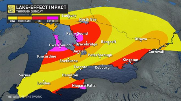
UPDATE NOV 17: Environment Canada has issued a snow squall watch for significant lake effect snow squalls Thursday night through to early Sunday morning affecting Prince Edward County through to to Kingston.
Squalls are expected to vary considerably – changing from clear skies to heavy snow within just a few kilometres.
Travel is expected to become treacherous or downright impossible during the heaviest bands of snow, where visibility may approach zero at times and roads will quickly become impassable due to rapid snow accumulation.
“Road closures are possible,” says Environment and Climate Change Canada.
It’s a classic setup for significant lake-effect snow — cold westerly and southwesterly winds blowing over the warmer lakes will lead to multiple bands of snow rolling onto the lakeshores.
Areas along Lake Ontario are at greatest risk for disruptive snow along the 401 in and east of Cobourg.
Due to the nature of lake-effect snow, storm totals will vary widely over short distances and between one community and another. Widespread totals of 25+ cm are possible throughout the region, with localized amounts of 50+ cm possible under the heaviest and most stubborn bands that develop.
The orientation of the winds will favour thick, persistent bands of snow over narrower, gentler bands, which will dump mounds of snow on some communities while others nearby will see more manageable totals.
The direction of the winds will play a key role in both how much snow falls and where the heaviest snows will occur.

Prince Edward County’s first snowfall of this season fell overnight with a little more, mostly flurries, on the way this week.
With temperatures above zero today, the snow likely won’t stick around long with rain showers and flurries forecast. More flurries are expected Thursday with a bit of sunshine poking through and daytime temperatures sitting around 2 degrees C.
Some towns may be welcoming Santa Claus this weekend with about 1-3 cm of fresh snow forecast to fall Friday and continue lightly into Saturday. If it sticks around through next week, it will help make the in-person Festival of Trees weekend at Isaiah Tubbs even more magical Nov. 25-27, and properly welcome Santa to Bloomfield and Picton.
Filed Under: Local News
About the Author: