
Lapsed Watermark sub-division phase 3 in Rossmore is re-approved
Administrator | Apr 16, 2026 | Comments 0

By Sharon Harrison
A new draft plan of residential sub-division application for 14 single detached residential dwellings for Watermark on the Bay (Phase 3) was approved by council, on the recommendation of planning staff. The decision is expected to be ratified at next Tuesday’s council meeting.
At Wednesday’s planning and development committee meeting, council heard how the applicant, having filed the original application 13 years ago, allowed it to lapse in 2017 before it received final approval. As the rules don’t allow a re-activation of the original approval, given the length of time that has passed, a new application must be filed in order to revive the previous approval.
The property was previously subject to a plan of sub-division application, draft approved on May 21, 2014 to sub-divide the land into 44 lots for single detached dwellings and two blocks for parkland to be constructed throughout three phases, the planning report notes.
Phase 1 and Phase 2 of the Watermark on the Bay sub-division have both been constructed, which resulted in the completion of 30 of the residential lots.
This current application relates to Phase 3 of the development, approximately 7.92 hectares in size, located at the current terminus of Navigation Drive in Rossmore (Ameliasburgh ward). It will bring 14 single detached residential dwellings (residential net density is about 2.5 units per hectare). It will also come along with parkland dedication of 1.61 hectares (20 percent), which is more than the five per cent recommended in the official plan. No amendments are being made from the previous draft approved plan of sub-division.
The proposed development will allow for in-filling and rounding-out of existing development by continuing the design of Phase 1 and Phase 2 of the Watermark on the Bay sub-division, notes the planning report.
Discussion around the horseshoe included stormwater drainage positioning, flooding and the 100-year floodline and the adjacent wetland area, affordable housing, as well as the length of time that has lapsed since the application was first filed.
Council also heard from three members of the public, including Paula Peel, representing the Prince Edward County Field Naturalists (PECFN), and Penny Morris, who each brought various concerns to light.
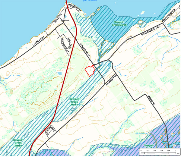 The lands are bound by a provincially-significant wetland (Sawguin Creek Marsh) to the east, with the Bay of Quinte located beyond. Property to the north is currently vacant.
Peel’s focus was largely on environmental issues, and by way of reminder, she began by saying that the application has sat dormant since 2017, with the reports that support the application having been finalized in 2013, where she noted that the environmental impact study (EIS), and any other reports, have not been updated since.
“It appears we have a very peculiar situation where there is not a single reference in the EIS since the County’s 2006 official plan,” stated Peel. “In other words, the EIS fails to identify or address a single environmental policy or strategy in this plan. This is a big gap in the EIS and it leaves an open question whether the applicant is even aware of the environmental policies in the official plan.”
“In PECFN’s view, accepting a very old and poorly done report like the Watermark EIS, that does not even mention the official plan, will set a bad example for other applications that are evaluated under the old official plan. It also undermines public trust that the natural environment will be protected.”
Morris spoke to the significant wetlands areas right beside where Phase 3 is due to be built.
“In this time of climate crisis, I think it behooves this council to take the necessary time and ensure 100 per cent that appropriate action is taken, whether that be a 50-metre setback,” expressed Morris, who also suggested the EIS be fully done.
She also addressed how the proposed homes do not offer affordable housing options as they will be very large, expensive homes.
Speaking to affordable housing, councillor Phil St-Jean asked if the developer has any consideration for lot configuration to allow for smaller residential dwellings, but Arnold Vandermeer, working on behalf of the developer, said the lots will not be re-designed.
“The only way you would see affordable housing is if they looked at an additional dwelling unit on the property,” said Vandermeer. “It’s a high market area and I think you would have an uprising very quickly if you put in low-priced affordable houses.”
The proposed development will be serviced by partial services with municipal water service and individual on-site sewage services, with the proposed residential lots larger in size to accommodate the on-site sewage systems.
Councillor Janice Maynard said the size of the lots was because there are no municipal sewers in Rossmore, where planning co-ordinator Samantha Deck confirmed the lots were sized accordingly because there is only partial services in Rossmore.
“It was a long time ago, but I do remember the original plan was to have some mixed density in there, but we couldn’t allow it because there is no municipal sewer services,” added Maynard.
Councillor John Hirsch said it’s important to understand that because of the length of time that the application has lapsed (more than five years), it has to be considered as a new application, and is therefore subject to the new provincial planning statement and the County’s new official plan.
Speaking to the environmental issues, Hirsch said, “It was a pretty poor EIS back then and a couple of things have changed. I don’t believe there has been a properly qualified person identify the wetland boundary, but the 100-year floodline has definitely changed since that application was approved.”
“We don’t want people buying lots discovering miraculously that they are under water when there is a 100-year event,” said Hirsch. “How can we ensure that the 100-year floodline will be respected, and the setback. Everybody needs to know where that new floodline is, and we don’t know where it is yet because its not in any of the documents we have.”
Vandermeer outlined briefly the background of the development noting how they had gone ahead with Phases 1 and 2, and had initiated Phase 3 where all the servicing had been done, including the watermain, stormwater management facility and the road work.
“Phase 3 took a little longer to get started, and there is still some vacant lots in Phase 1 and 2 as well that are trying to be marketed,” said Vandermeer. “The site has been fully cleared. We are basically on the home stretch, we are in another marketing season, and that’s why the urgency was in place to try and get this plan to be approved.”
Planning documents related to this application can be found on the County’s website.
Filed Under: Featured Articles
About the Author: